Along with the Spanish, British, and French, the Dutch sailed into the Caribbean centuries ago, planting their flag and leaving a legacy on six islands – Aruba, Curacao, Sint Maarten (only half of the island; the other half is French), Bonaire, Sint Eustatius (informally, Statia), and Saba. Over the years, they have formed an alphabet soup of connections – ABC for the three islands near the coast of Venezuela; SSS for the three much farther north in the Lesser Antilles; ACS for Aruba, Curacao, and Sint Maarten, now constituent countries within the Kingdom of the Netherlands; and BES for Bonaire, Eustatius, and Saba, special Dutch territories. Of all of them, Statia and Saba are ‘by-way’ islands – tiny, sparsely populated, and off the beaten tourist path. Which made them alluring to my husband and me back in the 1980s. Today I’ll return to Statia; next time, Saba.

Lower Town, Statia, courtesy Walter Hellebrand, Wiki Commons
Statia of the tour books:
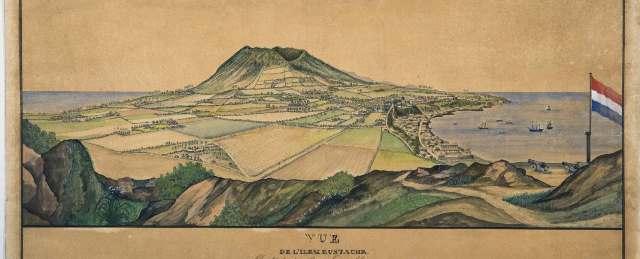
Shaped like a drop of water, Sint Eustatius scarcely reaches five and a half miles in length and three miles at its widest. An extinct volcano rises to the south, low-lying hills to the north, and, wedged in between, a sunbaked plain. Today, the plain encompasses a small airport, grazing land, and a dozen crisscrossed streets that make up the island’s lone town, Oranjestad, home to most of Statia’s 3,000 residents. Though teeny in size, Oranjestad boasts an Upper and Lower Town, boxy houses of stone or wood shingles, and neatly tended yards bright with bougainvillea. In Lower Town, dozens of stone walls and foundations are scattered along the beachfront and underwater, remaining testament to the island’s heyday three hundred years ago when Statia, nicknamed the Golden Rock, was the wealthy trading capital of the West Indies.

Statia in its heyday, courtesy Museum van Wereldculturen
Statia’s prime location in the heart of the Caribbean colonies (so prime it changed hands twenty-two times), its good anchorage and free-port status made it a veritable trade bonanza. Hundreds of two-story buildings were crammed cheek-to-jowl along a narrow mile-long street, and merchants hawked everything from sugar, ammunitions, and slaves to salted fish, wines, and colorful silks. In 1776, a fort above town gained fame for offering the first salute by a foreign government to the American flag on a U.S. naval vessel. Memorable stuff: however, before long, trade moved to more lucrative ports, and Lower Town fell to weather and neglect.
Today, Statia is known for its small resort hotels, several restaurants, snorkeling and diving around the underwater ruins, sightseeing land ruins including one of the oldest Jewish synagogues in the New World, hiking up the volcano, and enjoying the island’s friendly laid-back atmosphere.
My personal Statia:

Mount Mazinga, courtesy Walter Hellebrand
My husband and I hiked the Quill, the volcanic crater (kuil in Dutch) at the top of Statia’s Mount Mazinga. The crater is 1,900 feet high, 1,000 feet across, as symmetrical as a bowl, and smothered in rain forest. An hour’s steep hike got us to the rim. A path edges the rim through shadowy cloud forest to the opposite side. We took it. At the far side, the path mysteriously stops. Adventurous, we decided to complete the rim circle. Why not? Well, this is why not: at one point the rim is scarcely two feet wide (as I remember it), wedged between sheer drops many hundreds of feet to the crater floor and the sparkling Caribbean Sea. All these years later, I still shudder when I think of that two-foot wedge.