Chile is an elongated country, over 2,500 miles long and an average of 110 miles wide. Along its length, northern desert gives way to a lush valley, then lakes and temperate rain forests before the landmass begins to break apart south of the port city of Puerto Montt. Rugged strips of land crowned with peaks and glaciers abut vast fringes of islands in a deep-blue sea — the land of Patagonia. On my trip to Chile, I got to visit the northern reaches of this region, but the distances were too great, the time too short for me to get to Southern Patagonia. So I must become what everyone is these days — a virtual traveler.

Southern Patagonia Ice Cap and Lake O’Higgins, courtesy Aviva Imhof
Nature reigns:
Civilization takes a backseat to nature in all of Patagonia. Towns are small, few, and far between. National parks and reserves cover vast tracks of land, ideal for hiking and other nature pastimes. The southwest extension of the Pan-American Highway cuts through Northern Patagonia. Where it ends, around latitude 49° south, Southern Patagonia begins.
Land of glaciers:
The Pan-American Highway ends primarily because it comes up against a network of lakes and channels and the Southern Ice Field. At almost 5,000 square miles, this is one of the largest ice fields outside the polar regions. Straddling both sides of the Andes Mountains, it feeds dozens of glaciers in Chile and Argentina. Those in Chile in turn drip into the fjords and waters of the Pacific Ocean.
Epic ferry trips:

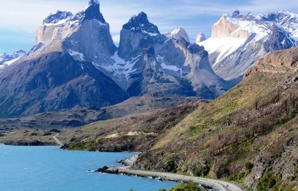
Torres del Paine, courtesy Alexa_Nbg
Most visitors to the region fly into the port cities of Puerto Natales or Punta Arenas, although the adventurous can take a ferry from Puerto Montt to Puerto Natales. The ferry trips, some three days and 1,200 miles long, wind through clusters of archipelagos containing thousands of islands and islets. Along the coast, rain forested mountains give way to grassy steppes and craggy peaks, and glaciers extend to the water in places. Winds are strong, temperatures are low, and precipitation – rain, snow, and sleet – is common. The ferries also take travelers to Bernardo O’Higgins National Park, the largest and least accessible park in Chile.
Cities at the ends of the earth:

Punta Arenas, courtesy Matthew Williams-Ellis
From the city of Puerto Natales, a road leads to the Torres del Paine National Park. World renowned and a UNESCO World Biosphere Reserve, Torres del Paine is a harsh, spectacular, and magical place of granite towers, rugged peaks, glaciers, turquoise lakes, grassy steppes, and beech forests – a hiker’s paradise. From Punta Arenas, cruises depart for the archipelago of Tierra del Fuego, Cape Horn, and Antarctica. This city began as a penal colony and later attracted many European adventurers seeking to make their fortunes in gold and coal mining, shipping and sheep ranching. In spite of its southernmost location, winter temperatures in Punta Arenas average a relatively balmy 30° F. On the other hand, summer winds can be fierce, and ropes connect buildings as an aid to pedestrians.
A hardier stock:
In spite of the harsh conditions, several indigenous communities led a nomadic life in Southern Patagonia before the influx of Europeans. Some lived on the mainland, stalking the llama-like guanacos with bows and arrows and dressing in animal hides. Others traveled from island to island in canoes, catching fish and hunting other animals to survive. Incredibly, many wore little in the way of clothing, keeping warm by rubbing themselves with animal fats and oils and tending small fires in their canoes.
And I complain when the house temperature drops below 68° F. . . .