Now that winter seems to be fading into an early spring, it’s time to get out the hiking boots and plan a few outings. Some of the best cool-weather hikes are along the Columbia River plateau, particularly so because by June the plateau becomes hot and rattlesnake-friendly. Two places here with memorable hikes are Steamboat Rock and the adjacent Northrup Canyon, both in Steamboat Rock State Park.

View from Steamboat Rock
A steamboat in the desert:

View from Banks Lake
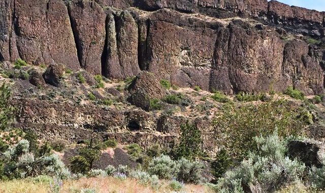
In the right light and with eyes half-closed, Steamboat Rock looks like a massive ghost ship marooned for an eternity on the waters of Banks Lake. In fact, the rock, a columnar basalt butte that rises 800 feet above the lake and surrounding desert landscape, has been there for what does seem to us an eternity – many millions of years. In more recent times, during the Ice Age floods, ice dams changed the course of the Columbia River, forcing it to rush south and form a wide channel known today as the Grand Coulee, leveling most everything in its path but the 600-acre steamboat-shaped butte. When the Grand Coulee Dam was built, the Columbia River returned to its original course and 27 miles of coulee below the dam became the Banks Lake reservoir.
The trail:

Wildflowers
Those who want to hike up the butte start at Steamboat Rock State Park, an area of campgrounds, docks and a swimming beach on Banks Lake. Several paths wind through dry sagebrush to the base. Here, a steep gap resembling an avalanche of loose rock splits the cliffs, providing a somewhat intimidating ascent. At the top, the terrain is relatively flat, and the views of the lake, lunarlike scablands, and distant mountains are stunning, especially so in the spring, when wildflowers are in bloom. For the best views, head north (right), where the trail skirts the edge of the cliffs.
Settling a canyon:

Northrup homestead
The same Ice Age floods formed Northrup Canyon some three miles to the east of Steamboat Rock. A trail connects the two sites, or you can park at the canyon trailhead off Road 155. The trail follows a picturesque mix of towering basalt cliffs, a small forest of pines and aspens, and historic structures, including a large pile of rusted cans left by Grand Coulee Dam workers. The canyon is named for a couple who settled here in the late 1800s, installed an irrigation system along a creek, and planted an orchard. Stage coaches and cargo wagons followed a road constructed around the same time along the canyon walls. Two miles from the trailhead, skeletal structures from the homestead remain as well as more recent buildings once used by park rangers.
Of water and birds:

Northrup Lake
Northrup Creek becomes a marsh in places, often forcing hikers to find alternate routes along the trail. A rather steep mile of walking beyond the old homestead leads to a lovely small lake in a basalt amphitheater. The combination of lake, creek, forest, and cliffs attracts a large variety of birds to the canyon, including hawks and bald eagles. It is an important winter nesting area for bald eagles, which can be viewed near the parking area. To protect the eagles, Old Wagon Road Trail is closed to hikers from November through March, but the trail along the canyon floor remains open year-round.
For more information about these hikes, consult Rich Landers’s hiking guides published by Mountaineers Books.

Canyon floor