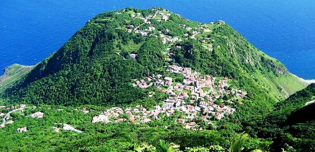
To the northwest of the Caribbean island of St. Eustatius [see my previous blog], a lone mountain pokes out of the sea. Underwater, the mountain’s flanks drop thousands of feet to the seabed; above, no beaches line the coast and the terrain is steep, with an impressive, long dormant volcanic peak on top. This is Saba, “the unspoiled queen of the Caribbean.”

Saba silhouette. Richie Diesterheft, Wiki Commons.
Geographical curiosities:
Saba measures less than three miles in diameter, a mere speck on the ocean. Fewer than 2,000 residents cluster in several small communities where the land is relatively flat. In spite of these humble statistics, its Mount Scenery, at 2,910 feet, is the highest point in the entire Kingdom of the Netherlands.
Getting there and around:
Early visitors likened Saba’s shape to that of Napoleon’s tricornered hat. On a horizontal outcropping of the hat, appropriately named Flat Point, lies a 1,300-foot landing strip, said to be the shortest commercial runway in the world. Flying in and out is often a white-knuckle experience, but the only alternative is by ferry from St. Marteen.

Windwardside. Radioflux, Wiki Commons.
Up until the early decades of the twentieth century, Saba had no decent harbor, and the only way to cross the island was on winding, steep step roads—some 200 uneven steps from Fort Bay to the seat of government at The Bottom; and countless more from The Bottom to Windwardside, a rural community where many homes resemble tidy gingerbread cottages. Dutch engineers said a concrete road for cars could never be built here, but local resident Josephus Lambert Hassell, armed with a correspondence course degree and his Saban crew, proved them wrong. Without the help of machines, the men created an engineering marvel in less than a decade.
A thumbnail overview:

Cliffs of Saba. Richie Diesterheft.
Several indigenous groups had lived on Saba for centuries before Columbus sailed by. He eyed its rugged hills and sheer cliffs and decided not to make landfall. Later, small groups of Europeans settled, and Saba was contested by the English (often enough that most Sabans speak English), Dutch, Spanish, and French until the Dutch won out in 1816. Saba’s population—descendants of slaves and of European settlers—remained small well into the twentieth century. For the most part, the two groups of descendants lived apart, and Saba is one of very few places in the Caribbean, or anywhere in the tropics, with a long-standing light-skinned population. A majority of Saba’s males, able seamen, left the island for years at a time, some never to return. The island was left with a preponderance of women, many of whom came to excel in lace work and other crafts.
In recent years, the island has seen an increase in tourism by off-the-beaten-track travelers who don’t mind the lack of permanent beaches. Popular recreational pursuits include hiking along mountain trails and scuba diving in pristine Saba Marine Park, which skirts the entire island. Stunning slopes and drop-offs feature unspoiled coral gardens and curtains of fish in kaleidoscopic colors. Since 1992, Saba University School of Medicine has provided an accredited alternative for U.S. and Canadian medical schools, with up to one hundred students a year attending its campus at The Bottom.
Our hikes:
When my husband and I visited Saba, back in the 1980s, we concentrated on hiking. The first day we took the most popular trail, from Windwardside up to the top of Mt. Scenery. A mostly paved path of a thousand steps plunged us into lush rain forest and gnarled cloud-forest vegetation before opening onto a spectacular view of the Caribbean as far as the eye could see. Though we were up and back in under three hours, our knees complained for days. We decided to forego a walk descending and ascending The Ladder, historic stepped route for men and donkeys hauling supplies from the coast to The Bottom.

Trail to Mt. Scenery. Richie Diesterheft.
The second day we arranged for a guide to take us along a trail starting at Hell’s Gate and more or less paralleling the north coast. It was a trail in name only, and we needed our guide to show the way through dry forest that opened onto spectacular coastal views. A couple of hours into the hike, we reached Mary’s Point. While my husband and I looked around for old bottles and other artifacts, our guide told us the story of the point. For centuries it had been an almost inaccessible hamlet, perched far from the main paths, and residents could spend their entire lives without leaving. The hamlet dwindled until, by the 1930s, Mary’s Point had only 32 people divided among eight families, and the effects of intermarriage were pronounced. In 1934, the government evacuated the hamlet and resettled the remaining residents near The Bottom.
We found very few traces of the old community.