Before the advent of the Internet, one of my most often used reference books was Roget’s Thesaurus. When I wanted to find the perfect synonym, I would look up the word and flip to the related site for dozens of similar words from which to choose. Today, I picked up the old thesaurus and searched for ‘blue.’ Under the blueness site I found all sorts of possibilities for a deep blue – azure, delft blue, cobalt, Turnbull’s blue, navy, midnight blue, indigo, ultramarine, sapphire blue, lapis lazuli blue. Why the search? All those shades and more can be seen, at different times of day and seasons of the year, in the waters of Crater Lake, Oregon.

What causes the lake’s intense blue?
To answer the question, we must go back in time, millions of years, when two immense slabs of rock known as plates, one under the Pacific, the other under North America, collided. Over vast amounts of time, the collisions formed a string of volcanoes along today’s Cascade Range. One of these volcanoes is Mount Mazama. Occasionally the volcanoes erupt, as happened with Mount St. Helens fifty years ago. Almost 8,000 years ago Mount Mazama erupted. [Tribes who inhabited the region at the time witnessed the event, and it has become part of the Klamath Tribe’s oral history.]

The top of Mount Mazama collapsed, forming a deep craterlike caldera. Located some 6,000 feet above sea level, the mountain gets rain and more than 43 feet of snow every year. Over the millennia, the rain and snow have fallen into the caldera, filling it up to become, at almost 2,000 feet, the deepest lake in the United States. No rivers, thus no sediments, flow into or out of the lake, resulting in some of the purest water in the world. Because of the depth and clarity, sunlight can penetrate deep into the lake, absorbing longer rays on the light spectrum and reflecting shorter rays, which consist of the violet/blue hues. And that is why the lake appears so blue.
The caldera:
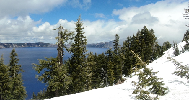
The caldera averages five miles in diameter, forming an almost perfect circle. Several cones poke up in the center, but only one, Wizard Island, rises above the water. The rim itself is jagged and uneven, towering almost 2000 feet above the lake in some places, 500 feet in others. The rock and pumice are of volcanic origin and give the rim a chalky gray appearance. Scatterings of pine trees grow on the less precipitous slopes as well as on Wizard Island. A road, open only in the summer, circles the lake, and there are many pullouts to park and take in the spectacular views. Unfortunately, the road can become congested, with jostling for available parking spaces. For those who want to touch the water, there is one trail. Located opposite Rim Village Visitor Center, it descends to Cleetwood Cove, where you can fish, swim in the chilly water (some 57 degrees F.), and take a boat to Wizard Island. The trail is short, scarcely over a mile one way, but it is steep and strenuous, dropping some 700 feet in switchbacks. It is not for the faint of heart or knees.
Sunlight is best:

Proof I was there — the second visit
I’ve visited Crater Lake twice. The first time was in early summer. The road to the lake didn’t seem precipitous, so it came as a surprise to see big drifts of snow everywhere. Clouds hovered overhead and rain, or perhaps sleet, threatened. The scale of the lake was spectacularly grand, but I had to use a lot of imagination to conjure up its indigo splendor. On my second visit, the day was sunny with mere wisps of clouds, and the water dazzled. It looked as if trillions of sapphires, lapis lazulis, and other deep-blue gems had been mixed and melted and spread from rim to rim. With luck and good health, I hope on my third visit to get to down to the lake, take the boat ride, and immerse my body ever so briefly in the pure water. However, it won’t be in 2020 as the boat tours have been cancelled due to the coronavirus.
Anything else?

View across the park in July
Though most visitors make a beeline to the lake, Crater Lake National Park actually encompasses over 180,000 acres. Roads lead to Pinnacle Valley, which resembles a forest of gray pine trees, and through the Pumice Desert. Trails take hikers to many peaks and points and a sphagnum bog. The Pacific Crest Trail cuts through the park from north to south, with an alternate section for Crest hikers who want to see the lake. There are many opportunities for biking and backpacking, and the park remains open for winter sports, accessible from the southern and western entrances.