The Mediterranean is vast—almost a million square miles of sea that extends 2,400 miles from east to west. Yet at its eastern edge it narrows to a mere nine miles known as the Strait of Gibraltar. To the north, on a small peninsula connected to southern Spain, a large limestone rock rises some 1,400 feet above sea level and resembles a great leviathan with a ragged, razor-thin spine. Regarded by the ancients as one of the Pillars of Hercules marking the edge of the known world, Gibraltar is a fabled spit of land, long haggled over by Spain and Great Britain. Although a Spanish friend of mine vowed his undying wrath if I ever stepped foot on Gibraltar, the British territory has long fascinated me as a gateway to different cultures that somehow coexist on one of the most densely populated places on Earth. Thus, my virtual journey to Gibraltar.

Gibraltar [Ayala, Wikipedia Commons]
In Paleo times:
A series of caves pock the Rock’s limestone walls at sea level on the steep southeastern side of the peninsula. Fifty to a hundred thousand years ago, during an icy age of lower sea levels, the caves lay some three miles inland and were inhabited by Neanderthals, who hunted on the coastal plain and in the sea, fashioned tools, and left rock engravings. One of the last refuges for Neanderthals in Europe, Gorham’s Cave Complex is today a World Heritage Site.

Gorham’s Cave Complex [Gibmetal77, Wikipedia Commons]
Moorish history in a name:
The word ‘Gilbraltar’ derives from the Arabic Jabal Tarik (Mount Tarik) in honor of a North African commander who landed on Gibraltar in 711 and went on to conquer the rest of the Iberian Peninsula. This began 750 years of Moorish rule in Spain. Remnants of that period on Gibraltar include fortifications, walls and towers, mosques and Moorish baths, and cuisine.
Of wars and shipping:
By the late 1400s Spain’s Christian kingdoms had defeated the Moors. Soon afterward on Gibraltar, a mosque near the southern tip was converted into a chapel and renamed the Shrine of Our Lady of Europe, still in use today. In the early 1700s war broke out over who would succeed the heirless king in Spain. Afterward, Gibraltar was ceded to Great Britain. Later in the century, Spain and France tried to retake the Rock, and the British excavated what are known as the Great Siege Tunnels. The siege failed. With the opening of the Suez Canal in the late 1800s Gibraltar became an important stop for trade ships. During World War II, it served as a base for the North African campaign, and the tunnels were expanded.
People, people, almost everywhere:
Today, some 34,000 people live in Gibraltar’s two-and-a-half square miles, and upwards of twelve million visit every year—this year of course being an exception. To relieve the crowded conditions, projects have reclaimed some land from the sea. The territory is a melting pot of British, Spanish, Moorish, Jewish, Maltese, Genoese, Indian, and Portuguese cultures. English is the official language and Llanito, Andalusian Spanish mixed with English words, the local vernacular. The older architecture is equally diverse and includes museums and historic gardens. On the western plain, modern highrises, marinas, casinos, promenades, hotels, shops and restaurants cater to residents and visitors alike. One road connects Gibraltar with Spain, and the wait to cross the border can be painfully long.
Monkeys and other curiosities:

Barbary macaque [Needpix.com]
The steep slopes of the Rock have discouraged development and today are protected in Gibraltar’s Upper Rock Nature Reserve. A couple of roads, primarily for tour drivers, crisscross the mount, and a cable car connects the city with one of the highest points. A number of sites up here definitely merit a visit. Several hundred tailless Barbary macaques (monkeys), concentrated at Apes Den, live on the Rock. Originally from Morocco’s Atlas Mountains, they are Europe’s only wild monkey population and, according to local legend, as long as they exist on Gibraltar, the territory will remain British. During World War II, Winston Churchill augmented the population with North African immigrants, just to be on the safe side.
A series of extensive caverns known as Saint Michael’s Cave has been known since ancient times and has sheltered inhabitants as far back as the Neanderthals. A large upper portion, Cathedral Cave, today hosts a multi-colored light show and houses an auditorium with excellent acoustics. A recently discovered lower cave (closed during the Coronavirus) leads down to an eerie underground lake. On the northwestern flanks of the rock, a fortification known as the Moorish Castle dates back to Arab times, and its box-shaped Tower of Homage remains a popular landmark.

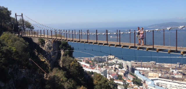
Windsor Suspension Bridge [visitgibraltar.gi]
For those without a fear of heights who crave spectacular views, the Mediterranean Steps links Jews’ Gate Cemetery with British batteries and the summit. Recently inaugurated, the Windsor Suspension Bridge spans a 150-foot gorge overlooking the city, and the Skywalk, perched on a skinny ridge atop a World War II lookout, consists of a transparent glass platform and walkway. Not for the faint of heart!
To take your own virtual tour of Gibraltar, log onto the following websites—https://gibraltar.com/and https://www.visitgibraltar.gi/
I did not know that it was still a surviving British Colony! I would love to visit there and I would dare to walk the suspension bridge.
Hi Randy,
I don’t think I’d be joining you! Check out the Gibraltar skywalk, too. It’s like the one at the Grand Canyon. I couldn’t do that, either — spending all the money only to stand shock-still with my eyes closed!
Thanks for commenting,
Kathryn