The Atlantic Ocean is vast, covering some twenty percent of the Earth’s surface, a roughly S-shaped mass of water bordered by North America and Europe to the north, South America and Africa to the south. It moves unimpeded between the continents, obstructed by only a scattered handful of small island archipelagos—to the west, the Caribbean; and to the east, the Azores, Madeira, the Canaries, and Cape Verde. Of all the eastern archipelagos, the Azores protrude most deeply into the mid-Atlantic—a thousand miles west of Portugal. Made up of three groupings, a total of nine islands, they span over 350 miles and are connected by ferries and small airplanes.

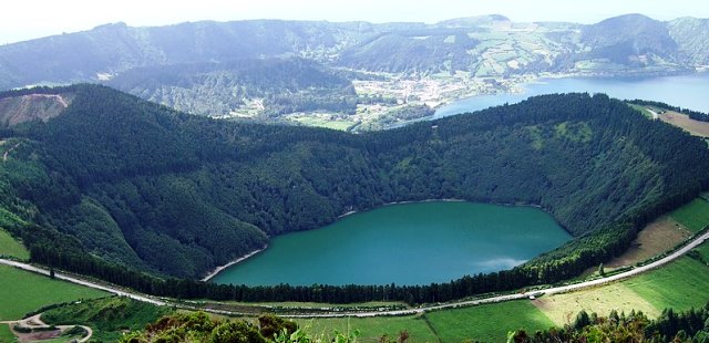
Caldera on Sao Miguel Island, courtesy Arnaud Mader
Macaronesia:
Macaronesia is an umbrella name given to these four eastern archipelagos, found off the coasts of southern Europe and northern Africa. The Azores islands began as tips of landforms thrusting upward from the ocean floor. Over the eons, volcanic processes raised the tips even higher until they broke through the surface of the ocean. The first island to poke above the water was Santa María, some eight million years ago; the last was Pico, 300,000 years ago. The Azores are uniquely located at the junction of three major tectonic plates—the North American, Eurasian, and African. They remain volcanically active: the most recent eruption occurred in 1957 off the coast of one of the smaller islands. The result of all this activity is a dramatic terrain of active and dormant volcanoes, ancient craters, hot springs, caves, coastal lava fields, and lava-formed tunnels.

Map of the Azores, courtesy Cristiano Tomas
A bit of history:
Like Madeira, the Azores are an autonomous region of Portugal. Long before Columbus set sail across the Atlantic, Portuguese navigators knew of and stopped at the uninhabited Azores, named for a Portuguese word for a type of hawk. Yet the Portuguese may not have been the first: a number of underground structures may be manmade, may date back 2,000 years, and may have been part of a Norse settlement. A lot of ‘maybes,’ but intriguing nonetheless. Other mysteries include coins that may have come from Carthage and a statue of a rider on horseback, possibly from the lost continent of Atlantis . . .
Populated in the 1400s by Portuguese settlers, the Azores also attracted a large number of Flemish farmers to its shores. For a time Spain ruled the islands and Britain raided them, but from the mid-1600s on, the Azores remained part of Portugal. Farms producing wheat, sugar, grapes, and other crops flourished, and ranchers raised sheep and cattle. The Azores became an important stopover for sailors crisscrossing the Atlantic and traders returning to the European continent.
Pick an island:

Mount Pico from Faial Island, courtesy Horst Evertz
Today, the Azores is an up-and-coming tourist destination, primarily for adventure travelers who like such activities as whale watching, scuba diving, hiking, and canyoneering, but also for festival music lovers and followers of religious processions. Each of the nine islands has its own feel.
Santa María, as the oldest, warmest, and southernmost island, has white sand beaches and rural landscapes. Pico showcases the cone-shaped mountain of the same name, highest in all of Portugal at over 7,000 feet. Angra de Heroísmo, a city of beautiful palaces and patterned streets and today a World Heritage Site, lies on Terceira, historically a prosperous trade island. Faial is home to hydrangea shrubs and an immense caldera; São Jorge has isolated farms, a coffee plantation, and basalt cliffs; Graciosa’s abandoned natural beauty includes vineyards and windmills, beaches, lava tunnels, and dive sites. To the west, Flores is rain-soaked and lush with lakes and waterfalls; and Corvo surrounds a large verdant crater.
São Miguel:

City Hall at Ponta Delgada, courtesy Diego Delso
The largest, most populated (140,000 residents), and most geologically diverse island is São Miguel. São Miguel contains the capital of Ponta Delgada, a cosmopolitan city with handsome white buildings, a vibrant university, restaurants and nightlife, and elaborate piers for boats of all sizes. More than twenty beaches ring the coastline, and there are several hot springs, a lovely botanic garden, craters with and without water, a winery, and a tea factory. Tour operators take visitors scuba diving, whale and dolphin watching, and canyoneering along cliffs and waterfalls. There are also hot-spring spas and hiking trails. In short, if you have one island to visit, São Miguel is your best bet.
Islet of Vila Franca do Campo:

Vila Franco Islet, courtesy size4riggerboots, Flickr
On the southern coast of São Miguel, to the east of Ponta Delgada, is a town called Vila Franca do Campo, a collection of whitewashed buildings and red roofs. Opposite the town about a kilometer offshore is a small islet of the same name. Low-lying vegetation covers craggy basalt cliffs surrounded by deep-blue waters. However, it is only when you approach the islet, or view it from above, that you understand its truly spectacular nature. The islet marks the remains of a crater from an ancient submerged volcano. The crater forms an almost perfectly circular, crystal-clear lake. Its opening, a narrow channel, faces inland, making it a spectacular, sheltered spot for bathing and snorkeling. It I could transport myself anywhere on the Azores, it would be to the tiny beach on this islet. There, I would be happy.