The Story: Ronda

Author’s note: To get the most out of this story, I recommend you first read the previous blog about the place. Thanks!

Day One:

Hands firmly on the wheel, Herbert steered the car around the outer edge of a hairpin curve. Beyond the road, he could gaze out on blue sky, shadowy mountain ranges, and, far below, deep-green olive orchards. He could, that is, if he wanted to get them both killed.

Curve completed, the car continued to ascend in the narrow outer lane.

“Damn you, Herbert!” His wife, Martha, pressed against the passenger door as if soldered to it. Her hands clung to each other for dear life, and all color had drained from her face. “Why in God’s name did you choose this road to get us to Ronda?”

“Guy at the car rental said it offered great views of rural Andalusian countryside.” Herbert shrugged. “He didn’t mention the conditions.”

“And you didn’t think to ask?” Martha’s breaths came in ragged spurts. “You know I have a deathly fear of heights.”

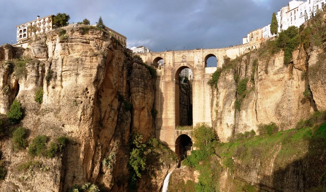
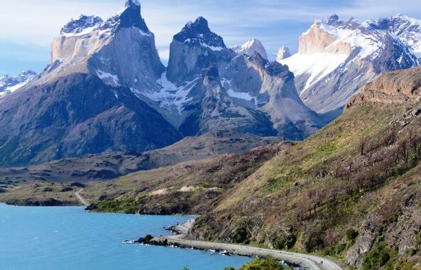
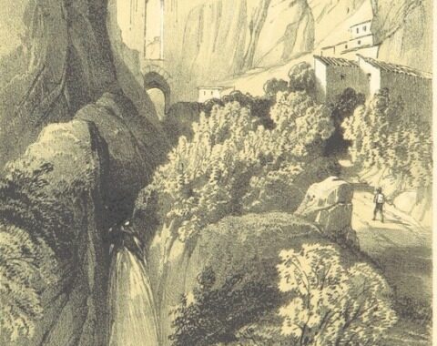
Half-an-hour later the Dansons arrived in Ronda, a small city perched like a white-washed bird’s nest on top of rugged cliffs. They made their way along a street hemmed in by homes, small shops, and tapas eateries, most painted white, with red tile roofs and black grillwork. The street ended at the Ronda Parador, a luxury hotel fashioned from a former city hall.

“Here we are,” Herbert announced as he exited the car and opened the passenger door. Martha had to catch herself to keep from tumbling onto the pavement, and she held her husband’s arm until the jelly in her knees solidified.

After unpacking, showering, and dressing in clean clothes, Martha and Herbert carried two glasses of Rioja wine out on the lawns surrounding the hotel. “Here’s to our long-awaited trip to Spain,” Herbert toasted, and they clinked glasses.

“Let’s check out the gorge.” Hand under Martha’s elbow, Herbert led her to a stone wall. La Taja Gorge, some 400 feet deep, bisected the city and made Ronda famous. In front of them, a massive stone buttress bridge blended with the cliffs. As Herbert approached the wall, Martha’s steps slowed, then stopped entirely, and she extricated her elbow. Herbert leaned over. Below the dam, the Guadalevín River swan-dove into a pool on the gorge floor.

“Herbert, you’re way too close.” Martha stood her ground three feet back.

“There’s a waterfall. Come take a look.” He reached for his wife, who retreated in fear. “Martha, we have a wall here. No way you can fall over.”

Martha shook her head. “I read a study. People who have a fear of heights often have equilibrium problems, and if they get too close, they can lose their balance and topple over.”

“That’s just silly.” Herbert walked away from the wall, and they finished their wine on lounges next to the hotel pool.

Day Two:

“I don’t know why you insist on making me join you on these hare-brained adventures.” Martha inched the ball of one foot onto a lower step, then eased the other foot and the rest of her body down to join it, all the while clutching a flimsy handrail for support. “We’re too old for this.”

‘This’ was a tunnel of steps built by the Moors in medieval times to transport water from the river below to the town above. Hundreds of uneven, damp, and poorly lit steps, if one took the time to count them. Martha tried. Along the way were crevices, crannies, and a chamber known as the room of secrets; why, she wasn’t sure. It seemed the perfect setting for a not-so-cozy murder mystery, of which she had several lined up to be read in her hotel room.

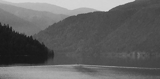
“We can look at the pool at the bottom of the gorge. You like lakes.”

Martha snorted. “I like them from a chair on a pontoon boat, not this way.”

When they got to the bottom, Martha caught her breath while Herbert studied the bridge spanning the gorge. “Amazing engineering feat,” he commented.

Day Three:

“What happened, Señor Danson?” The police officer patted his close-cropped mustache as he focused shrewd eyes on Herbert.

Herbert’s face contorted in grief. “Martha wanted to view the bridge at dawn. Take photos to send the grandkids. She saw something below that caught her attention. The reflection on the pool, maybe. Or a bird. She loves birds.” He pulled at a strand of hair. “I told her not to get too close . . .” He covered his eyes with his hands.

For a moment, neither spoke. “Did you wife have a fear of heights?” the officer asked.

Hands still covering his eyes, Herbert shook his head. “No, heights didn’t bother her at all.”

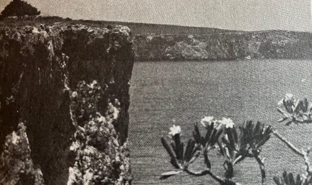
[photo Ronda from A Summer in Andalucia, George Dennis]

The Place: Ronda, Spain

2020 is the year my husband and I have planned to take a trip to Europe and spend time in Spain, which I haven’t visited since my junior-year-abroad in college. Of course, we all know about best-laid plans in the time of the coronavirus. Though there’s no way to know when my body will get to Spain, I can do a bit of virtual traveling. Scrolling around the Internet, I zeroed in on the small city of Ronda as a fine place to visit.

Ronda-Andalusien-iStock-472031208

Ronda [Urlaubsguru]

At home in the eagles’ nest:

Ronda perches atop craggy cliffs surrounded by mountains in Spain’s southern Andalusian region. White-washed buildings with red tile roofs and black grillwork cluster together on both sides of a 400-foot-deep gorge known as El Tajo. South of the gorge sits Ronda’s Old Quarter, where some of the cobblestoned streets are so narrow cars cannot pass. Far below, on the gorge floor, flows the Río Guadalevín.

Getting there:

Isolated on its hilltop perch, the city connects with the coast along the dramatic Ronda-Marbella Road. A winding, sometimes dangerous series of hairpin curves opens onto breathtaking views of rolling hills, olive orchards, and snow-topped mountain ranges. From Algeciras on Spain’s southernmost tip, passengers can board Mr. Henderson’s railway. Built by the British in the 1890s to connect Gibraltar with Madrid and points beyond, the train today passes through lovely rural landscapes on its way to Ronda.

Outpost or crossroads?

Santa_Maria_la_Mayor_Ronda_Malaga-1

Santa Maria la Mayor [Wikimedia commons]

In spite of its outpost location, Ronda has existed, and been fought over, for thousands of years. In the sixth century B.C., the Iberian Celts chose the well protected site for a settlement. Subsequent waves of Romans, Greeks, and Visigoths left their marks before the Moors conquered the region. The Arabs remained for almost 800 years, until the late 1400s, when they in turn were ousted by the Castilian Catholics to the north. Mosques were converted to churches, the best-known being Iglesia de Santa María la Mayor. Only one brick and stone minaret is left, but the Moorish influence in Ronda remains strong in its architecture, foods, and customs.

Lodging in style:

Puente Nuevo (New Bridge) and El Tajo gorge in evening light

Puente Nuevo [Wikimedia Commons]

Spain’s world-renowned paradores offer luxury hotel accommodations in historic buildings—castles, convents, fortresses, and the like. The Ronda Parador, set in a former town hall, hugs the edge of the gorge and offers stunning views of the countryside, the city,  and its iconic bridge. Although known as Puerto Nuevo (new bridge), it was built in the late 1700s. Stone arches and buttresses blend in with the cliffs, and, at the bottom, a waterfall spews into the river below. In addition, the parador restaurant serves a number of regional specialties, including stewed partridges, cold garlic soup, and sweet egg-yolk flans.

Palaces:

The Casa del Rey Moro is a palatial building that, in spite of its illusion to a Moorish king, was actually built in the 1700s, long after the Moors were expelled; its Moorish-styled gardens were added in the early 1900s. The Moors did build the Water Mine below the palace to collect water from the river below. Some 300 cliff-carved steps lead down to a lovely river pool, and adventurous tourists with good knees can follow in the footsteps of the water-collectors. The nearby Mondragon Palace, a local history museum, does date back to Moorish times.

A bullring:

ronda-bull-spain-bullring-preview

Plaza de Toros, Ronda [PickPik]

Ronda’s Plaza de Toros is one of the most handsome and legendary in Spain. Two tiers of covered seating amid Moorish-styled arches and columns look out on a ring of sand over 200 feet in diameter. It was built in the 1700s, during the golden years of Ronda’s most famous son, the bullfighter Pedro Romero. Romero, considered the father of modern bullfighting, changed the face of the sport, which dates back to the first millennium A.D., from one of raw courage to a true art form. Within the white-washed building is a museum dedicated to bullfighting. Outside, new memorials honor two famous men drawn to bullfighting in general and Ronda in particular – Ernest Hemingway, who apparently celebrated his last birthday in Ronda, and Orson Welles, who had his ashes buried here.

There’s more:

Most of my virtual visit to Ronda took place at two websites. A delightful in-depth history of the city can be found at Andalucia.com. And Ronda Today is fun in many ways.

The Story: Sullivan Lake

Author’s note: To get the most out of this story, I recommend you first read the previous blog about the place. Thanks!

Doreen Roark sat in a folding chair on the beach at the northern edge of Sullivan Lake. Behind her, a maze of paths led through evergreen forest to the site where the Roarks were camped for a week. In front of her, iron-blue water slapped at pebbly gray sand. The lake, half a mile wide, curved between hills blanketed by forest. The sun was low in the sky, its rays gently warming her skin. She slipped a cover-up over her bathing suit and repositioned her chair to make the most of the remaining light. Lowering a floppy-brimmed hat over her face, she opened a mass-market mystery. Her eyes remained on the lake and a brood of children scampering in the shallow water.

Her own two daughters were with her husband, Doug, in the nearby community of Metaline Falls. Earlier, he’d offered to take them for pizza at a small restaurant on the main street and bring her back a couple of slices. No campfire cooking, no clean-up, time alone to enjoy the serenity of the lake – it was near perfect. Thanks, Doug.

Before long, the children left the beach, trailed by their mother half hidden under a collection of towels and inflatable toys. Doreen waved, and the mother responded with a grimace and a wagging pinkie.

Doreen nestled deeper into the chair. The lake had flattened out to resemble a dark sheet of glass. The sun was gone, and the sky slowly wrung itself of color. Forested hills became charcoal silhouettes. Scents of sunscreen gave way to that of pine resin. Silence settled in, broken only by occasional distant squeals of children playing at their campsites. A God’s-in-his-heaven-all’s-right-with-the-world moment. Doreen gave off a long, deep sigh of contentment.

Moments later, a truck pulled into the adjacent parking area, its headlights forming two harsh cones on either side of her chair before they and the motor were extinguished. Doreen turned to see a woman wearing a T-shirt and shorts, no shoes, exit from the driver’s side. No one was with her. Stooped in the shoulders and curved in the spine, she resembled the misshapen trunk of a bonsai tree. From the back of the truck, she wrestled with a squat kayak, the sort used for journeying down whitewater.

“Need any help?”

Whatever the woman mumbled was lost on Doreen, but a stiff shake of the head made her reply clear. Doreen watched out of the corner of her eye as the woman tipped the kayak on to the ground, retrieved a paddle, and dragged both across the pebbly beach to water’s edge. In the final light of day, the woman’s face – eyes, skin, and a short fringe of hair – took on an unnatural gray. For a long time, she stood, statue-still, in front of the lake. Then, with what could have been a shrug or a shudder, she pushed the kayak into the water, lowered herself in, and began to paddle.

No life jacket. Doreen rose from her chair with the intention of reminding the woman of the law, then pressed her lips shut. A lot of older people tended to sneer at such safety measures as seatbelts and life jackets; this woman was most likely one of them.

Doreen watched until the kayak was little more than a bug on the water, trailed by two faint threads of white. Once again, she sat in the chair, hands on book on lap. The sky, now dark, framed a lustrous moon and thousands of pinprick stars. Crickets chanted their monotone din.

After a bit, her husband and daughters joined her on the beach. The younger daughter handed her a take-out pizza box.  “Pepperoni.”

Doreen handed it back. “You guys go on to the campsite. I’ll meet you there, and have the pizza with a glass of wine. I want to stay out here a bit longer. An elderly woman crossed the lake alone in a kayak. I want to stick around to make sure she gets back.”

Two hours later, Doreen gave up her vigil and joined the rest of the family. First thing in the morning, she walked to the beach. The truck was still there. She notified the authorities, who found the kayak in the middle of the lake, but no body. Several days later, the body floated to the surface, and authorities declared the mishap suicide by drowning.

For years to come, Doreen wondered if the woman had noticed the magnificence of the lake that evening, and why it hadn’t been enough.

The Place: Sullivan Lake, Washington

From the time I went on church retreats as a girl and had to rise early, find a solitary spot on the banks of a lake, and think spiritual thoughts as the fog slowly vanished over the water, I have associated lakes with serenity. I’m drawn to most any kind of lake, but perhaps the one in the Inland Northwest that comes closest to perfection for me is Sullivan Lake.

Sullivan Lake 1

Sullivan Lake, East Sullivan Campground

A few facts:

1EEE64DB-A96A-42B7-8A25-F19B2EB718C6

Clear water

Located in Colville National Forest in northeast Washington, Sullivan Lake nestles in the foothills of the Selkirk Mountains. Some four miles long, its shape resembles a squat worm. Though it reaches a depth of 320 feet, the water is clear and relatively comfortable. Half a dozen homes are scarcely seen in bordering forest. A road skirts the lake to the west, a hiking trail to the east, and two popular campgrounds on both ends. East Sullivan Campground (to the north by my account) has a long beach and an airstrip for small planes. Fishing enthusiasts catch trout, kokanee salmon, and burbot (a type of cod), and sightseers arrive in late October to view the aspen and western larch in golden splendor.

Nearby places of interest include Metaline Falls, 6,000-foot-high Hall Mountain, trails into the Selkirks, Gardner Cave, the Boundary Hydro-Electric Dam, and Z Canyon for kayakers.

First encounters:

I first saw Sullivan Lake when we were visiting my in-laws while still living in Puerto Rico. We stopped for lunch at a small café on the main street of Metaline Falls. Long ago a settlement for native Americans, more recently for traders, miners, and lumberjacks, Metaline Falls today is a scenic community of a scant 250 residents. After lunch, we viewed a small reservoir known as Mill Pond along Sullivan Creek. [The pond no longer exists as the dam was recently removed to return the creek to its natural state.] Our final stop was Sullivan Lake. The day was chilly, the campgrounds in deep forest shade, and the lake, when I stuck my hand in, seemed — compared to the Caribbean — dauntingly cold.

The great crossing:

07C2951B-69EA-4E82-A94F-90ECD5F6E954

The rock

Several years ago my husband and I, now living in Spokane, drove to a small motel near Sullivan Lake. The first day, he took off to climb Gypsy Peak, and I headed to East Sullivan Campground. New to navigating lakes, I’d only recently graduated from a large inner tube to a good quality inflatable kayak. First, I opted to hike most of Lakeshore Trail, some four and a half miles long, as it wound through lush cedar forest before following the edge of the lake. By the time I got back to the day-use site and onto the water, the winds had whipped up. I paddled hard for quite some time, only to reach a relatively close strip of beach, where I saw a beautiful quartz rock the size of a large hand. Though I wanted to take it with me, I feared tearing my new kayak and decided to return the next day with a towel to pick it up.

Sullivan Lake 2

Me and my kayak

My husband and I got there early, and off I went. The water was calm as glass, mine was the only vessel to be seen, and I skimmed forward effortlessly. After a bit, I started searching for the strip of beach with the rock. It couldn’t be found. Paddling farther, I passed one point after another, tiring but refusing to turn back: the beach had to be just around the next bend.  One more bend, and my heart leaped to my throat: in front of me was the opposite end of the lake. I had kayaked almost four miles! Suddenly nervous at my daring, I stroked back with great care. Relatively close to the campground, the strip of beach with the rock came into view.

The moral — you can go a lot faster and farther when there’s no wind.

Epilogue:

Every summer, my husband and I plan a trip to Sullivan Lake, he to hike in the Selkirks and I to paddle on the lake. One summer we missed when there were fires in the area. And this summer? It would be bleak indeed if the coronavirus keeps us away.


The Story: Southern Patagonia

Author’s note: To get the most out of this story, I recommend you first read the previous blog about the place. Thanks!

Six scientists in a small outboard boat approached the island of Santa Inés in Chile’s Southern Patagonia. They motored into a deep fjord surrounded by rocky cliffs patched with trees, shrubs and tufted grasses. Thick clouds covered the highest pinnacles. The lip of a glacier extended to the water. Sea lions cavorted around their boat.

Tying the boat to a spindly tree next to the glacier, they hiked up the ice and battled hurricane-strength winds to reach the top of a hill. From there, they watched in horror as the winds ripped their boat from its mooring and sped it across the water toward the center of the fjord.

The winds kept up. In order to escape certain death from hypothermia, the group – five men and a woman – struggled down the opposite side of the hill toward the center of the island. There they hoped to find a protected spot in which to wait until other members of the expedition noticed their absence and came to their aid.

For hours they crossed an inhospitable landscape. Breathing became difficult; they often fell and struggled to rise. Ahead rose tiers of gray ridges dusted with snow. They scarcely had the energy to climb the first one.

As they descended, the woman, Sara, gestured the others to stop. She pointed. “Doesn’t it look greener to the left, in that valley? Or am I hallucinating?”

The others saw it as well. With renewed energy, they headed for the valley. It displayed  a lushness they hadn’t seen elsewhere. Temperatures rose: they began to feel warm in their parkas, and their skin tingled painfully as it returned to life. Taking off the outerwear, they left it in a pile. Farther up the valley, the forest became tropical. Tree ferns lorded over bananas and oranges.

“If this is a dream, may I never wake,” said Ethan, the medical expert.

They soon came upon a lake, sapphire-blue, and on the banks of the lake a single log cabin and half a dozen primitively made wooden boats. A man sat in a rocking chair on the cabin porch. He appeared old, with lizard-textured skin laced in wrinkles and a mound of matted white hair. His shirt and pants were hand-sewn.

“Hello!” Ethan waved to the man as they approached. “Do you speak English?”

“I do.” He spoke with an accent. “Not much though. Visitors are rare here.”

Introductions completed, the old-timer, whose name was Cayenne, explained he had discovered the valley decades earlier. Finding everything he needed, he never made an effort to leave.

“And no one else has come here?”

Cayenne shrugged. “A few. It is a desolate region. Most avoid it. None have stayed.”

Cayenne offered to make them tea. While he was in the cabin, the others spoke among themselves.

“What an astounding find.”

“A paradise at the ends of the earth.”

“Can you imagine establishing a research center here? Warm temperatures, water, fresh fruits and vegetables, yet a stone’s throw from the unexplored regions of Southern Patagonia.”

“Or a camp for extreme sports enthusiasts? People would pay big money for such a set-up.”

A curtain in a cabin window fluttered back in place. Cayenne appeared with a pot of tea and seven cups hewn from local gourds.

“Tea from leaves in the valley,” the old-timer said as he poured.

“What a beautiful lake.” This from Sara.

“The water is warm. You must try it after your tea.”

“Why so many boats?” another member of the expedition asked.

Cayenne observed the boats. “You can never tell when you might need an extra one. There are many fish in the lake,” he added by way of explanation.

Sara looked with longing at the water. “Can we take one out?”

“Of course.” Cayenne’s eyes turned to slits when he smiled.

After they finished their tea, the five dragged a boat to the lake’s edge. Sara dipped her fingers in the water. “Ooh, it’s as warm as a bath.”

Cayenne retrieved a pair of oars from the cabin and brought them to the boat. “If you row toward the center of the lake, the water is even warmer. A perfect place for a swim,” he told Sara.

They rowed across the lake. The old-timer was right: the water became warmer. Soon it began to roil, and the steam had a distinct smell of sulfur.

“The water is boiling!” Ethan shouted. “Turn back. Quick.”

Before they could, scalding water began to seep in.

“The resin holding the boat together is melting. We’re going to sink!”

“We’ll burn to death!”

On shore, Cayenne sat in his chair and rocked for a spell, watching as the boat and its occupants slipped beneath the water.

The Place: Southern Patagonia, Chile

Chile is an elongated country, over 2,500 miles long and an average of 110 miles wide. Along its length, northern desert gives way to a lush valley, then lakes and temperate rain forests before the landmass begins to break apart south of the port city of Puerto Montt. Rugged strips of land crowned with peaks and glaciers abut vast fringes of islands in a deep-blue sea — the land of Patagonia. On my trip to Chile, I got to visit the northern reaches of this region, but the distances were too great, the time too short for me to get to Southern Patagonia. So I must become what everyone is these days — a virtual traveler.

3767151946_b6e80bdc0b_b

Southern Patagonia Ice Cap and Lake O’Higgins, courtesy Aviva Imhof

Nature reigns:

Civilization takes a backseat to nature in all of Patagonia. Towns are small, few, and far between. National parks and reserves cover vast tracks of land, ideal for hiking and other nature pastimes. The southwest extension of the Pan-American Highway cuts through Northern Patagonia. Where it ends, around latitude 49° south, Southern Patagonia begins.

Land of glaciers:

The Pan-American Highway ends primarily because it comes up against a network of lakes and channels and the Southern Ice Field. At almost 5,000 square miles, this is one of the largest ice fields outside the polar regions. Straddling both sides of the Andes Mountains, it feeds dozens of glaciers in Chile and Argentina. Those in Chile in turn drip into the fjords and waters of the Pacific Ocean.

Epic ferry trips:

patagonia-2325073_1280

Torres del Paine, courtesy Alexa_Nbg

Most visitors to the region fly into the port cities of Puerto Natales or Punta Arenas, although the adventurous can take a ferry from Puerto Montt to Puerto Natales. The ferry trips, some three days and 1,200 miles long, wind through clusters of archipelagos containing thousands of islands and islets. Along the coast, rain forested mountains give way to grassy steppes and craggy peaks, and glaciers extend to the water in places. Winds are strong, temperatures are low, and precipitation – rain, snow, and sleet – is common. The ferries also take travelers to Bernardo O’Higgins National Park, the largest and least accessible park in Chile.


Cities at the ends of the earth:

Punta Arenas, Magallanes and Antartica Chilena Region, Chilean Patagonia, Chile

Punta Arenas, courtesy Matthew Williams-Ellis

From the city of Puerto Natales, a road leads to the Torres del Paine National Park. World renowned and a UNESCO World Biosphere Reserve, Torres del Paine is a harsh, spectacular, and magical place of granite towers, rugged peaks, glaciers, turquoise lakes, grassy steppes, and beech forests – a hiker’s paradise. From Punta Arenas, cruises depart for the archipelago of Tierra del Fuego, Cape Horn, and Antarctica. This city began as a penal colony and later attracted many European adventurers seeking to make their fortunes in gold and coal mining, shipping and sheep ranching. In spite of its southernmost location, winter temperatures in Punta Arenas average a relatively balmy 30° F. On the other hand, summer winds can be fierce, and ropes connect buildings as an aid to pedestrians.

A hardier stock:

In spite of the harsh conditions, several indigenous communities led a nomadic life in Southern Patagonia before the influx of Europeans. Some lived on the mainland, stalking the llama-like guanacos with bows and arrows and dressing in animal hides. Others traveled from island to island in canoes, catching fish and hunting other animals to survive. Incredibly, many wore little in the way of clothing, keeping warm by rubbing themselves with animal fats and oils and tending small fires in their canoes.

And I complain when the house temperature drops below 68° F. . . .


The Story: Steamboat Rock and Northrup Canyon

Author’s note: To get the most out of this story, I recommend you first read the previous blog about the place. Thanks!

The sun had not yet risen. Lauren moved in ghostly half-light, searching for any signs of life in the loose rock at the base of the canyon cliffs, any tufts of green that could provide nourishment. She found none.

When the sun rose above the cliffs, baking the landscape, she sought shelter in a small cavity in the basalt rock. It would be another day without food or drink. Resting in the cavity, she observed movement on the canyon floor as late risers took up their own desperate searches for sustenance.

Northrup Canyon had not always been such an inhospitable place. When Lauren was just a baby, a stream had flowed here for most of the year. There were fruit trees, vegetable gardens, birds and other small animals. It was a modest life, but they wanted for nothing.

Until the drought came—year after long year of no rain. The creek dried up, becoming little more than a strip of mud, then it too dried up. Families dug ever-deeper wells, but eventually they proved not deep enough. Gardens no longer sprang up, the trees withered, and wildlife vanished. Babies died first, followed by children with matchstick arms and distended bellies. The highest point in the cliffs became known as The Leap, for those who’d lost all but the hope of reuniting with their departed. After her mother and two brothers died, Lauren’s father had chosen The Leap.

At the end of the day, when long shadows fingered into the canyon, Maxim approached the cavity where Lauren sat. The concept of friendship had dried up along with everything else, but Lauren considered Maxim someone she could trust.

“I’m thinking of heading over to Steamboat,” he told her.

Lauren spit on the ground. “Why?”

He shrugged. “Maybe something fell off the cliffs that we could use.”

The difficulty of walking three miles battled the possibility of finding a morsel of food.

“Okay, I’ll go with you.”

Steamboat Butte. The very words stirred up loathing among the canyon survivors. On the upper plateau of the enormous butte lived a community of a dozen families. They had everything they needed to flourish—gardens, fruit trees, wheat fields, pigs, goats, and an unending supply of water. Eight-hundred-foot vertical walls protected the plateau, except for one narrow, steep gap in the rock. The Steamboaters had erected a wall across the gap, and guards patrolled the wall night and day. Beggars, refugees, old acquaintances—anyone who tried to pass through the gate in the wall was executed, no questions asked.

The source of their unending supply of water was a mystery. Some believed a wizard lived in the community and worked his magic to bring the water. “Not true,” Lauren’s father had told her. “Wizards don’t exist. I bet there’s an engineer, or maybe a hydrologist, up there, someone who knows how to find water and get it to the top of the plateau.” He may have been right, but that hadn’t helped him or his family.

When they reached Steamboat, Lauren and Maxim began to circle the base. On the eastern side, a final beam of light from the setting sun exposed a crack in the basalt just wide enough to permit two skeletal humans to slip through. They inched their way from dusk to darkness.

Lauren stopped. “I don’t want to go any farther.”

Maxim touched her shoulder, then placed his finger across her mouth. They listened. Through the throbbing silence came the sound of gurgling water.

And that was how Lauren and Maxim, who later married and had a child, found water. It was soon channeled into Northrup Canyon, and guards were stationed at the crack in the butte with orders to execute anyone who approached them, no questions asked.

The Place: Steamboat Rock and Northrup Canyon, Washington

Now that winter seems to be fading into an early spring, it’s time to get out the hiking boots and plan a few outings. Some of the best cool-weather hikes are along the Columbia River plateau, particularly so because by June the plateau becomes hot and rattlesnake-friendly. Two places here with memorable hikes are Steamboat Rock and the adjacent Northrup Canyon, both in Steamboat Rock State Park.

Steamboat 2

View from Steamboat Rock

A steamboat in the desert:

Steamboat 1

View from Banks Lake

In the right light and with eyes half-closed, Steamboat Rock looks like a massive ghost ship marooned for an eternity on the waters of Banks Lake.  In fact, the rock, a columnar basalt butte that rises 800 feet above the lake and surrounding desert landscape, has been there for what does seem to us an eternity – many millions of years. In more recent times, during the Ice Age floods, ice dams changed the course of the Columbia River, forcing it to rush south and form a wide channel known today as the Grand Coulee, leveling most everything in its path but the 600-acre steamboat-shaped butte. When the Grand Coulee Dam was built, the Columbia River returned to its original course and 27 miles of coulee below the dam became the Banks Lake reservoir.

The trail:

Steamboat 3

Wildflowers

Those who want to hike up the butte start at Steamboat Rock State Park, an area of campgrounds, docks and a swimming beach on Banks Lake. Several paths wind through dry sagebrush to the base. Here, a steep gap resembling an avalanche of loose rock splits the cliffs, providing a somewhat intimidating ascent. At the top, the terrain is relatively flat, and the views of the lake, lunarlike scablands, and distant mountains are stunning, especially so in the spring, when wildflowers are in bloom. For the best views, head north (right), where the trail skirts the edge of the cliffs.

Settling a canyon:

Northrup Canyon 1

Northrup homestead

The same Ice Age floods formed Northrup Canyon some three miles to the east of Steamboat Rock. A trail connects the two sites, or you can park at the canyon trailhead off Road 155. The trail follows a picturesque mix of towering basalt cliffs, a small forest of pines and aspens, and historic structures, including a large pile of rusted cans left by Grand Coulee Dam workers. The canyon is named for a couple who settled here in the late 1800s, installed an irrigation system along a creek, and planted an orchard. Stage coaches and cargo wagons followed a road constructed around the same time along the canyon walls. Two miles from the trailhead,  skeletal structures from the homestead remain as well as more recent buildings once used by park rangers.

Of water and birds:

77B691CA-AAFD-4E46-8E09-F3729FE4D69D

Northrup Lake

Northrup Creek becomes a marsh in places, often forcing hikers to find alternate routes along the trail. A rather steep mile of walking beyond the old homestead leads to a lovely small lake in a basalt amphitheater. The combination of lake, creek, forest, and cliffs attracts a large variety of birds to the canyon, including hawks and bald eagles. It is an important winter nesting area for bald eagles, which can be viewed near the parking area. To protect the eagles, Old Wagon Road Trail is closed to hikers from November through March, but the trail along the canyon floor remains open year-round.

For more information about these hikes, consult Rich Landers’s hiking guides published by Mountaineers Books.

Northrup 4

Canyon floor


The Story: Mona Island

Author’s note: To get the most out of this story, I recommend you first read the previous blog about the place. Thanks!

1698:

With a final violent push, the surf scraped a dinghy over razorlike coral reef and jammed it onto a small pocket of beach. When it hit the bone-white sand, the boat splintered in two. A sailor was cast from the boat onto a beach, where he lay as lifeless as the metal box next to him. Roiling clouds darkened the sky, rain plunged in diagonal sheets, and gusts of winds flattened coastal shrubs.

When the sailor regained consciousness, the hurricane had churned its way beyond the horizon. He glanced around at debris left behind – dinghy fragments, dead fish, sodden twigs – before his eyes lit on the metal box. With sudden clarity, he remembered the events of the last twenty-four hours, and a smile played on his lips.

His pirate ship had just passed a small island in the middle of the Mona Passage when a hurricane the ship had been dodging for days turned and headed its way. Pandemonium broke out as the crew prepared for the storm’s fury. At that moment, inspiration struck the sailor. No one would be guarding the captain’s personal treasure. He snuck into the captain’s quarters and pulled out a metal box filled with gold and silver coins. As he was leaving, the ship’s cook spotted him and threatened exposure if the sailor didn’t include him in the heist. Together, they untied a lifeboat, slid into it with the treasure between them, and rowed fiercely into a roiling ocean.

A perilous, even suicidal undertaking, but the rewards … ah, the rewards. Enough for the sailor to live comfortably the rest of his life.

His life.

When a large wave collapsed on the boat, the cook fell overboard, surfaced, and grasped the gunwhale with his hands.

“Help me!” he shouted above the din of the storm.

With his oar, the sailor struck the cook’s hands. Repeatedly.

“Damn you!” the cook shouted as his grip slipped from the hull. “A curse on you and your ill-gotten treasure!” A subsequent wave swept him under the water.

Now safe on the beach, the sailor caressed the metal box. Rising, he took stock. He was on tiny Mona Island, where he knew from other sailors there was a spring, feral pigs, and deep caves for hiding out. Sea grapes and coastal thicket separated the beach from a limestone cliff pocked with cavities. He noticed a shadowy, toothy hole near its base that looked promising. Pulling the metal box across the sand, he made his way to the cave.

A twisting passageway extended far into the cliff. Though the box was heavy and he had difficulty dragging it along the uneven floor, the sailor continued until only the tiniest ray of light lit the chamber. Even that wasn’t enough: he and the treasure must be completely hidden from any of the captain’s men who might come after him. He took measured steps through silent blackness.

One more step, and his foot touched the edge of a deep cavity instead of solid rock. His hands, still wrapped around the heavy box, could not stop the fall. He landed hard, breaking both legs in the process. At the bottom of the cavity, unable to walk and imprisoned by darkness so complete it obscured any sense of direction, the sailor could only wait for someone to save him.

No one did.

Over the centuries, Mona Island saw its share of pirates and treasure hunters, farmers and miners, biologists and cosmologists. Of the hundreds who arrived, perhaps half a dozen came upon the sailor’s desiccated bones and tattered clothes scattered around a metal box. When they opened the box, they discovered coins that let off an eerie light and burned the skin of those who touched them.

No one did more than once.

The Place: Mona Island, Puerto Rico

Something new:

Up until now, I’ve written about places in three different regions – Chile, the Inland Northwest, and Puerto Rico. I’m now adding a new stop, using sites in multiple regions as settings for mini-stories inspired by them.  One week, you’ll get acquainted with the place; the next week, its story.  Let’s start with Mona Island, a setting worthy of many stories, the more ghostly the better.

Mona_Island,_Puerto_Rico

Scrub forest along the coast (Wikipedia)

And we begin:

Mona Island pokes up in the middle of Mona Passage, halfway between Puerto Rico and Hispaniola (Dominican Republic /Haiti), a stubborn remnant of the time, millions of years ago, when a long, flat super-island extended from Cuba to the Virgen Islands. That this seven-by-four-mile, lima-bean-shaped island endures in the notoriously rough passage is nothing short of miraculous.

Mona_Landsat7_Pseudo

Satellite photo

A bit of history:

Over thousands of years, indigenous groups settled the island, the last wave being the Tainos, who used the island as a link in their Caribbean canoeing journeys. They enjoyed a simple life – raising crops, living in communal thatch bohíos, and gathering at ceremonial ball courts – until Europeans arrived in the New World. By the end of the 1500s, Tainos were gone from Mona. For more than three centuries, the respectable steered clear of the island, and it became a refuge for pirates and privateers, the best known being Captain Kidd. This brought a surge of quixotic seekers of buried treasure. Eventually, an operation for mining guano (bat and seabird poop, used as fertilizer) helped reestablish a degree of respectability. Today, Mona is a nature reserve. It has no permanent inhabitants, only rangers and biologists, adventure tourists and in-season hunters who stalk the feral pigs, goats, and cats that stalk endangered native species.

A Galapagos of the Caribbean:

B6A44EA8-365D-4A71-8EC3-6578CC8B5302

Cliffs and alelí tree

Because of its distinct geological formation, its isolation, and its relative lack of development over the centuries, Mona  shelters many natural curiosities. A dramatic limestone plateau looms over 200-foot cliffs to the north, then flattens out to several  strips of white-sand beach along the other coasts. Deep ragged-toothed caves riddle the cliffs, and spectacular reefs and marine life – including endangered hawksbill turtles – populate exceptionally clear waters. Sunning on rocks, the yard-long Mona ground iguana resembles a creature of the dinosaur age. Land and hermit crabs scuttle about in the hot, dusty scrub forest. Cacti grow next to alelí trees, which, at certain times of years, blossom in a rare burst of color across the landscape. Boobies and a variety of seabirds nest on Mona and the smaller Monito island to the northwest.

Tall tales:

EF85705E-27C8-472B-9828-A6DF2B34DC8C

Beachside cave and (insert) brown booby

A number of natural and supernatural tales have arisen from Mona’s colorful history. Tales of Captain Kidd’s stay on Mona and the treasure he stored deep in a cave. Murdered maidens crying at night. Pirates who lost their heads. A farmer poisoned by liquor intended for a hated ship captain. A woman who lived in a cave and cooked for the guano miners. Treasure seekers who went crazy, drowned at sea with their new-found booty, or were seen in San Juan dressed in finery.

And my own tale, which I’ll post next time.