The Story: The Great Ocean Walk

  Author’s note: To get the most out of this story, I recommend you first read the previous blog about the place. Thanks!

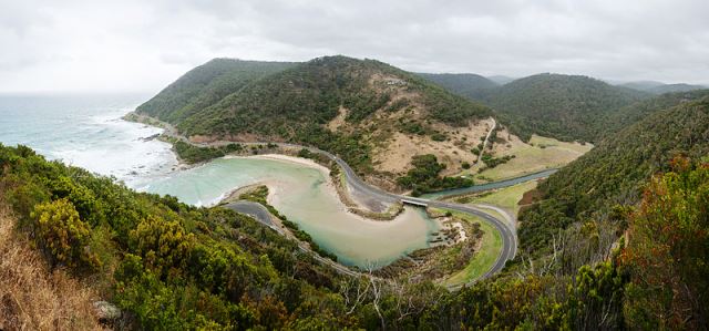
George picked his way along the bluff as the last rays of sunlight dimmed and the pastel sky faded. In the distance, gray fingers of the Loch Ard Gorge defied the Southern Ocean, enduring even after eons of pounding surf.

Choosing a spot free of brush, George set his backpack on the ground. He rummaged inside for an energy bar, pulled the water bottle from a side pocket, and sat next to the pack.

“Dinner,” he announced to no one. Alternating food and drink, he focused on the line separating the now-dark ocean with a sky only slightly lighter.

In mid-afternoon, George and his hiking buddies had reached the giant stack formations of the Twelve Apostles, end-of-the-line for the Great Ocean Walk. After years of vowing to do the trail one day, they’d finally flown to Melbourne from Sydney and took a bus to Apollo Bay, start of the walk—one hundred ten kilometers spread out over eight days. Eight days of following dirt paths, steps, and boardwalks. Of taking in remote pale-sand beaches, shrub-forested peninsulas, rolling waves, reef rocks, and koala bears, plus the occasional lighthouse, river, and kangaroo. While they waited for a bus to take them back to the start of the trail, they spoke eagerly of how they would celebrate in Apollo Bay.

All but George. The healthy simplicity of walking, eating, and sleeping amid spectacular views had drawn him to the natural world. The stresses in Sydney, of a job he didn’t like, a girlfriend who didn’t seem to like him, too many peopled living amid too much concrete—all that lessened in importance. Happy here, he wasn’t ready to go back.

“Let’s take one more night and walk to Loch Ard Gorge tomorrow,” he had suggested as they stood at the bus stop.

The others answered with groans and boos. “Are you kidding?” This from Jerome, his oldest friend. “No way. I’m famished. All I want is an ice-cold beer and a couple of burgers.”

So, they parted company. George didn’t mind, not entirely. His world was now even simpler—no need for conversation, no reminders of Sydney. After his modest dinner, he spread a ground cloth, unrolled his sleeping back, and crawled in. For evening entertainment, he watched a trillion stars until he fell asleep.

In the morning, the sun rose, and dazzling color returned to the landscape. The cliffs took on reddish hues, the peninsulas a deep green. Long, low clouds draped the ocean horizon. George ate his last energy bar, packed up, and started toward the gorge. He could now walk all day and not grow tired, and his pack, though it still bulged, weighed less. Invigorated, George took great gulps of unpolluted air and set off.

The outlines of the cliffs ahead resembled horseshoes, and surf battered a scattering of large boulders offshore. Overhead, clouds moved across the sky, followed by dark stormy masses. When George reached the Tom and Eva Lookout, rain sputtered in large drops. The wind turned fierce, and salt spray drenched him. He stepped onto the lookout platform, covered his pack with the ground cloth and slipped on a poncho.

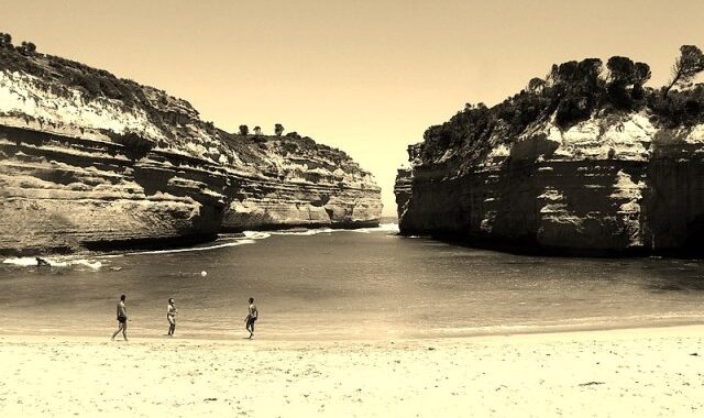
The bay below was shoebox-shaped. It lined a narrow beach, and cliffs on both sides framed two massive pillars, all that remained of a famous arch that had collapsed a decade earlier. The pillars had been given the names of Tom Pierce and Eva Carmichael, according to a platform placard, the only survivors of a disastrous 1878 shipwreck. The Loch Ard, an iron clipper ship with 54 people on board, en route from England to Melbourne, had gotten caught in thick fog and foundered on the cliffs of Mutton Bird Island, partially visible from the platform.

Just such fog swept across the sea, then the outer tips of the gorge, the island, the pillars, and finally the cliff in front of George. It erased everything, but he could still hear the ocean rage and waves boom against the cliffs. Gale-force winds sounded like lifeguard whistles as they shrieked past him. The rain increased. He sorely regretted his decision to stay here another night.

A short walk led to the Loch Ard Gorge parking area. From there, he knew, steps descended to the beach, where overhangs and a cave could protect him. Walking quickly, he fought the wind and deluge and stepped carefully down the slick steps. Once on sand, he noticed the barely visible outline of a cave to his right. Inside, he flicked water off his poncho and gave thanks to be out of the wind and rain.

In spite of the shrieking storm, George nodded off. When he woke, the rain had slackened, and he could make out cliffs almost touching in the distance, forming an inverted V-shaped cove that widened into a pale-sand beach. Waves crashed against the cliffs.

On the beach, a boy flapped his arms wildly. He wore what looked like culottes and a vest, of a coarse and tattered muslin. His brown hair lay plastered to his face, his body shook, and his eyes bulged in terror.

George approached. “You’re shivering. Come into the cave,” he instructed. “Take off your clothes, and you can crawl into my sleeping bag.”

The boy’s eyes skidded from George to the ocean beyond the cliffs. “Were you on the ship?” His voice broke.

George felt a pounding in his head. A shipwreck? He saw no sign of one from the cove. The coast guard must be contacted, but there would be no signal here.

“No. I’ll go up to the cliffs, but first, come into the cave.”

The boy shook his head and turned to the water. George grabbed his wrist, and they struggled. “The ocean’s too rough. You’ll die out there. Tell me your name; let me help you.”

The boy went limp. “Thomas,” he said. “Thomas Pierce.”

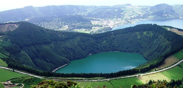
[photo of Loch Ard Gorge, portengaround, Wikipedia Commons]

The Place: The Great Ocean Road, Australia

I took a personal interest in Australia decades ago, when college friends talked of emigrating there (they never did). It has always remained in my mind as a faraway place of immense skies and wide-open semi-desert landscapes linked by rough, straight, unending roads. If pressed to name three of the country’s top destinations, I’d list the Sydney Opera House, the Great Barrier Reef, and Uluru/Ayers Rock. Wanting to find something a bit more off the beaten path for this virtual journey, I did some research and came up with The Great Ocean Road along Australia’s south coast, overlooking the Southern Ocean in the state of Victoria.

Ocean Road, Bobak Ha'Eri, CC

The Great Ocean Road. Photo by Bobak Ha’Eri, Creative Commons.

The State:

Victoria nestles in the extreme southeastern sag of the continent, across the Bass Strait from Tasmania. It is the second smallest state in terms of land and the second largest in population. A gold rush in the mid-nineteenth century brought people and wealth to the region. Today, it is a diverse cultural hub, with numerous Aboriginal groups and large immigrant communities. Its capital, Melbourne, houses most of the state’s population. The second-largest city in Australia, it features museums and galleries, riverside bars and restaurants, and is dubbed by some as the world’s sporting capital, particularly for the Australian versions of cricket and football.

The World’s Largest War Memorial (or at least the longest):

At the end of World War I, a rugged stretch of coastline in southwest Victoria was accessible only by sea or rough bush tracks. At the same time, many soldiers returned from the war without jobs or prospects. Several men with a vision obtained funds to build a road here in order to connect isolated coastal settlements, increase logging and tourism, and provide employment for the returning servicemen. Some 3,000 men worked on the project, now known as the Great Ocean Road. Begun in 1919 and completed in 1932, hewn primarily by hand and extending some 150 miles, the route became a war memorial for the soldiers who died in the war.

Of Surfing and Shipwrecks:

Ocean Road, Cape Otway Lighthouse, CC, Dietmar Rabich

Cape Otway Lighthouse. Photo by Dietmar Rabich, Creative Commons.

The road begins at the surfing town of Torquay, a three-hour drive from Melbourne. The first half of the route hugs the Surf Coast, where powerful winds sculpt the coastal water. Just beyond Torquay, the huge waves of Bells Beach make it Australia’s most famous surfing spot. At the midway point is Cape Otway. A side road detours through koala country to the dazzling white Cape Otway Lighthouse, perched on 300-foot cliffs. Beyond the cape, the road rambles along what is referred to as the Shipwreck Coast, a rugged landscape of towering limestone cliffs and deep gorges, with tales of several tragically famous shipwrecks out of hundreds that occurred here over the centuries. At Wreck Beach, anchors remain from two of them. The road winds through rainforest, cuts through picturesque seaside towns, and connects to pristine beaches, making this one of the most spectacular driving routes in the world.

Self-Driving the Route:

Ocean Road, CC, Lorne, David Iliff

Coastline near Lorne. Photo by David Iliff, Creative Commons.

Though the Great Ocean Road may seem off-the-beaten-path from my armchair in Washington State, more than eight million people drive it every year, making for dense traffic on weekends and holidays. The road itself is two-laned and paved, with much winding and many twists. Numerous turn-offs enable faster drivers to speed onward, and slower ones to stop and breathe a sigh of relief. Most websites suggest taking at least three days to do the route justice.

Along the way:

Processed with VSCO with c7 preset

Erskine Falls. Photo by Ari Moore, Creative Commons.

The ocean is always close at hand, but landscapes change. West of Torquay, the red-capped Split Point lighthouse shares an inlet with the village of Aireys. A short drive north from the town of Lorne is Erskine Falls, a 100-foot waterfall nestled in a tree-fern gully. This is part of the Great Otway National Park encompassing coastline, waterfalls, rainforest, California redwoods, koalas, paths, and picnic areas.

Ocean Road, 12 Apostles, CC, Jess Miller

Twelve Apostles. Photo by Jess Miller, Creative Commons

Beyond Otway, limestone takes center stage. The most famous site here is the Twelve Apostles, a grouping of stacks up to 150-feet high that rise above the shallow coastal waters. Over the eons, wind and saltwater have eroded the limestone cliffs, resulting in caves, arches, pillars, and other formations. Originally referred to as the Sow and Pigs, the Apostles were renamed to give them greater respectability, in spite of the fact there were only nine stacks at the time, reduced to eight today. Go figure. Nearby, the spectacular Lock Ard Gorge, named for a local shipwreck, features blue waters, a pale-sand cove, and a massive archway that collapsed in recent years.

Ocean Road, Joanna Beach, CC, wanderingchina

Joanna Beach campground. Photo by wanderingchina, Creative Commons.

The Twelve Apostles can also be reached from a trail that begins in Apollo Bay. Known as the Great Ocean Walk, it is almost 70 miles long, hugging the coastline and passing through two national parks. Eight days are recommended for the hike, and there are campgrounds along the way (reservations required) and fancy resorts nearby.

The route officially ends at the town of Allensford, but many drivers continue to the small city of Warrnambool. From either place, there are roads—faster, less winding, actual highways— leading back to the city of Geelong and from there to Melbourne. I imagine not too many drivers opt to turn around and take the Great Ocean Road back.

The Story: Clear Lake, California

Author’s note: To get the most out of this story, I recommend you first read the previous blog about the place. Thanks!

“The businessman was back.”

Setting her tablet on the chair next to her, Luna tilted her head slightly and squinted at her husband. “Was he?”

Fenn nodded. “Auryn’s going to fold.”

Luna sighed. “I feared as much. She’s weak.”

“Weakness can’t be abided.”

“What will you do? With the businessman, I mean.”

Fenn rubbed his beard. “I’ll talk to the others. Same as before, I suppose.”

Luna stood, walked to the entrance of their home, and opened the door. Like all lake dwellers, they lived in a small structure tunneled into the side of a hill. On the outside, only brightly painted doorways distinguished one home from another. Earthen walls kept them cool in summer and warm in winter, eliminating the need for artificial air control. Solar panels powered lighting and the appliances used in cooking and cleaning. Furniture, of sturdy wood composite, was built to last for several generations, and body suits, received upon reaching adulthood, lasted a lifetime. Reduce the human imprint on the land—that was the pledge of lake dwellers.

Luna’s doorway had been painted a greenish-beige to match the tule reeds that grew in the wetlands around the lake. Auryn’s doorway, a vivid violet, matched nothing. She was Luna’s neighbor, but because her property was one of the largest along the lake, they rarely came in contact with each other. A widow whose children had left the lake to become city dwellers, Auryn was a soft touch for every businessman who came along. They all wanted the same thing—to buy her property and alter it to suit the needs of urban dwellers looking to escape the polluted air and tainted water in the cities.

“I’m going to the lake.” Luna gathered her hat from a rack by the door. “I’ll bring back fish.” Most of the protein in their diet came from fish, supplemented by waterfowl and an occasional deer.

Fenn waved and returned to his woodworking. Like his father and grandfather before him, he built the beds, tables, and chairs found in lake-dwelling homes. Most of the furniture he used as barter for other items he and Luna needed, but when coins were required for something special, he sold pieces to city firms. Luna spent her days reading on her tablet, preparing meals, and going to the lake, where she fished, paddled, swam, or just relaxed.

She started down the path. Oaks and pines provided partial shade. Above the canopy, cottonball clouds skitted across a deep blue sky. On a bend in the path, the forest parted and the lake came into view. Her heartbeat always quickened at the sight. A vast sheet of transparent blue water stretched across the horizon and fingered into forested hills on the far side. Hundreds of birds circled overheard, waiting to pounce on fish nudging to the surface. Children scampered along the beach and in shallow waters, and fishermen paddled boards into the deeper areas. The lake was beautiful, healthy, and abundant, giving them all they needed to live good, simple lives.

As far back as lake dwellers could remember, the lake had been healthy. And yet . . . there were stories, told in whispers around campfires at night, of a time eons ago when the lake was dying. Its waters shrank, exposing slopes of desiccated soil. Fires raged. Algae and toxic plants produced poisons. Fish and waterfowl died. Humans suffered from rashes and often fatal sicknesses, and many starved.

No writings remained from those times, but the lake dwellers carried deep in their bones a communal consciousness to leave nature alone and harm the lake in no way. When the local gnats proved especially bothersome, residents wore mesh nets over their heads. When algae bloomed and stank, they paddled to other parts of the lake to bathe and fish until the bloom subsided. No one wanted to do anything to cause a return to the terrible times of the dying lake.

Of course, city dwellers had other views, views of progress and changing the lake to suit their needs instead of the other way round. City dwellers couldn’t help but tinker.

Fenn and the others took it upon themselves to make sure they didn’t.

**

“The businessman won’t be back.”

Luna tilted her head slightly and squinted at her husband. “Won’t he?”

Fenn nodded, then closed his eyes and took a deep breath. “It’s done—until the next time.”

The Place: Clear Lakes of the Western States, USA

‘Clear Lake’ is a descriptive if somewhat overused name for bodies of water large and small. In Washington alone, a quick search on the Internet turns up three Clear Lakes and one Clear Lake reservoir; in Oregon, there is a Clear Lake and a Clear Lake reservoir; only in California did I find no competition. My ‘personal’ Clear Lake here in Spokane County, WA is spring-fed and covers 350 acres. It has a slender body set between forest and stubby cliffs, and a shallow fringe of hidden ponds and channels. Shelter for all kinds of birds and even a moose or two, it is often the place I go for my first kayak outing in the spring.

On a recent road trip from Spokane to southern California, I added two more Clear Lakes to my personal list. One of them tantalized from afar, the other mystified up close.

Clear Lake Spokane County WA

Clear Lake, Spokane County, WA

Clear Lake, Willamette National Forest, Oregon:

Clear Lake Sisters Mountains OR

Three Sisters Mountains, OR

The Clear Lake here proved to be a victim of the road not taken. On our drive home from southern California, we left the southern Oregon coast at Florence, and, after passing through Eugene, followed the McKenzie River east. In spite of recent forest fires, the drive was spectacularly beautiful. Beyond the community of McKenzie Bridge, we had to make a decision—curve north along Route 126 or take the more rugged McKenzie Pass–Santiem Pass Scenic Byway, closed in winter. We chose the latter, and with its eye-popping vistas, snow-capped mountains, lava fields, old-growth forests, and a curious observatory built of lava rock, didn’t regret our choice.

Clear_Lake_Dock_Gary Halvorson, Oregon State Archives

Clear Lake, OR. Photo by Gary Halvorson, Oregon State University.

The other way, along 126, would have led us past Clear Lake. Nestled in Oregon’s High Cascades, this is a small (142 acres) gemlike mountain lake and the source of the McKenzie River. Lava from a volcanic eruption some 3,000 years ago dammed it naturally and, in the process, submerged existing forest under 120 feet of water. Remnants of those underwater trees still exist. Fed by a stream and filtered through lava rocks, the water here is crystal clear and strikingly blue. With visibility up to 200 feet and a white volcanic silt bottom, Clear Lake is a paradise for wet-suited scuba divers; however, with average water temperatures scarcely above 40 degrees F, it is not so enticing to swimmers. I hope to return one day. However, to paraphrase Robert Frost, way does lead on to way, and there’s a good chance I may never get back.

Clear Lake, Lake County, California

Clear Lake Redwood NP CA

Redwood National Park, CA

On our drive down to southern California, we followed Oregon’s southern coast and California’s northern counterpart, spending an hour or so amid the giant trees of Redwood National Park, then headed inland along a patchwork journey toward San Francisco Bay. Looming large on the map ahead of us was an impressive body of water known as Clear Lake. As car navigator, I chose a northern route around the lake to give us close-up views. Descending a bend in the road, the lake appeared as a vast body of water shimmering a faded ghostly blue. Surrounded by semi-arid mountains, it should have beckoned us, an oasis on the landscape, but something seemed off. Modest homes and trailer parks lined the banks of the lake cheek by jowl, but we didn’t see families romping along the shoreline or boats skimming the water. The lake seemed full yet numerous rundown wooden docks extended like diving boards eight to ten feet above the surface. We didn’t stop; I didn’t take photos. Was there a prettier side of the lake along a different road? Perhaps the docks were fishing piers? Was this a reservoir, another victim of the region’s severe drought? Later, I did some research.

Clear_Lake_Ca_-Federico Pizano, Panoramio

Clear Lake, CA. Photo by Federico Pizano, Panoramio.

Clear Lake is not a reservoir; it is a natural freshwater lake. At almost 44,000 acres, nineteen by eight miles at its widest, this is actually the largest freshwater lake entirely within California (Lake Tahoe is partly in Nevada), set amid some of the cleanest air in the nation. What’s more, its existence dates back two and a half million years, making it the oldest lake in North America, with volcanic remnants on the south side. It is quite shallow, with an average depth of twenty-seven feet, and warm in summer. Largemouth bass abound along with other fish, waterfowl, and animals that inhabit the nearby hills. Native American tribes have lived along Clear Lake for more than ten thousand years and, against historic odds, continue to celebrate their cultural ties to the lake. It has long been known as a popular place for watersports, with resorts, marinas and watercraft of all sorts, skiing, sailing, fishing, kayaking, and swimming, and today several wineries sprawl across the surrounding hillsides.

However, something is wrong, the age-old tale of too much human interference. At one time, wetlands rich with tule reeds surrounded the lake, filtering the water and keeping it clear; as of today, eighty-five percent of the wetlands have been destroyed. Native hatch once spawned here in the millions; now, in the mere thousands. Invasive aquatic plants and mussels proliferate. Algae blooms, including toxic cyanobacteria, have always existed in the shallow waters but never in the abundance seen today. All of this is due to a complex variety of factors—deforestation, construction, fertilizers, wastewater discharge, seepage from a local mercury mine. One human interference popularized in Rachel Carson’s book, The Silent Spring, dealt with the Clear Lake gnat, a non-biting insect so prevalent it made life miserable for humans. The pesticide DDD was applied to control the gnat population, and it in turn contaminated the eco-system and decimated waterfowl populations.

And on and on.

There is hope. We now have a much better understanding of ecology, and projects are underway to counter some of the negative effects on Clear Lake, with modest success. May the work continue.

The Story: The Tiger’s Nest

Author’s note: To get the most out of this story, I recommend you first read the previous blog about the place. Thanks!

 “When people are fearful of something, they tend to avoid the feared activity. Although this avoidance might help reduce feelings of fear in the short-term, over the long term it can make the fear become even worse. In such situation, a psychologist might recommend a program of exposure therapy.”

Sarah refolded the brochure along well-worn creases and replaced it in her backpack. A dozen tourists milled about on the valley floor, waiting for the guide to start them on the trail. She stepped apart from the others and looked up, stretching her neck in the process. Bhutan’s Tiger’s Nest monastery resembled a miniature that had been painted onto the top of a vertical three-thousand-foot cliff.

“Time to start,” the guide announced. “Ready? Let’s go!” A local, he wore a traditional Bhutanese knee-length robe and spoke with an awkward bonhomie. The other tourists sprang into action, sprinting to the start of the trail in their excitement. Sarah let them go first.

What am I doing here?

She laid all the blame on her former boyfriend. That he had dumped her seemed grossly unfair. Sarah was modestly pretty, appropriately social, reasonably athletic, and, from a family inheritance, financially set for life. It wasn’t her fault she was deathly afraid of heights and Franklin was an avid mountaineer. “I can’t share my passion with you,” he’d pointed out with increasing frequency before the break-up, his passion being high-altitude camping, trekking along steep paths, scrambling and summitting peaks and ridges.

The break-up devastated her, and she grasped at the only way she knew to revive the relationship—overcoming her lifelong acrophobia. After several sessions with a psychologist, she advanced to direct in vivo exposure by crossing a low-lying swinging bridge. It was a modest victory at best: she completed the challenge on her hands and knees, reciting a Biblical passage. Then she learned Franklin had started dating a woman from his climbing gym. Sarah needed to up the ante, to flood her exposure, starting with the most difficult task instead of the easiest. A photograph of the Tiger’s Nest had hung in the lobby of her college dorm, giving her goosebumps every time she’d passed it. I’ll start there, she decided.

The trail, of hard-packed earth, seemed easy enough as it ribboned through pine woods.

I can do this.

She placed one foot in front of the other and regulated her rapid breathing. Soon the ascent steepened. She concentrated on the trail, which remained lined with trees. When the view opened up to show a vast panorama of the valley below, she hugged the inner edge of the trail.

I can do this.

At the halfway point, the group stopped at a café strewn with colorful prayer flags for an obligatory tea. Sarah averted her eyes from the drop-off below. The monastery loomed much closer, a tableau now instead of a miniature. They were heading toward it at an angle, but every possible way up seemed terrifying.

“Congratulations!” the guide enthused. “You have reached a spectacular view. The trail beyond will become increasingly more difficult. Some of you may prefer to turn around here. A van will take you back to Paro, and we can meet up later.” Sarah’s heart crashed around in her chest, but she stood with the group who would continue upward. The guide scanned her with concern.

No longer did the vegetation cushion her from the abyss beyond. The altitude was higher, the trees more scraggly. She walked with mincing steps, her body sore from leaning away from the cliff, her limbs the consistency of overcooked pasta. Every glimpse to the abyss splintered her. Her heart struggled like an animal in a cage, and she felt she was breathing something thicker than air. Then the trail angled downward; the valley lurched into view, and she crouched as she walked.

I can’t do this.

Where a bridge crossed a small waterfall, the guide approached her. “You look sick,” he said, without any of his earlier enthusiasm. Sarah eyed the stone steps ahead of her, once again ascending, and at the monastery temples, which looked as if they had been pasted onto the vertical granite.

“Help me,” she croaked.

For the rest of the ascent, the guide held her hand, and a fit woman in the group followed behind, a hand on Sarah’s hip. For her part, Sarah kept her eyes closed. After what seemed a thousand steps, they reached the entrance to the temple.

“Oh. My. Goodness. What a view,” the woman exulted. “Open your eyes, dear, and take a look.”

Sarah didn’t. Instead, she walked into the main temple, curled up in a fetal position on the cool floor, and sucked her thumb, something she hadn’t done since the first grade.

**

It took a private helicopter to pull Sarah, cocooned and with a hood over her face, off of the monastery and back to the city of Paro and her plane rides home. Her acrophobia worsened, but, as a silver lining, she no longer had feelings for Franklin.

Several years later, she met a man with absolutely no interest in sports; they married and lived a long and happy life together.

The Place: The Tiger’s Nest, Bhutan

A large photo of Bhutan’s Tiger’s Nest monastery, also known as Paro Taktsang, hangs in my dermatologist’s office. Whenever I pass it, I get a tingle up my spine. The tingle comes in part from the dramatic beauty of the Buddhist temple and in part from its precarious position tacked onto a vertical granite cliff thousands of feet above a lush valley. ‘Yikes,’ my acrophobic mind cries out, ‘if I ever got up there, I’d never get down.’

Tiger's Nest, Douglas J. McLaughlin

Tiger’s Nest, courtesy Douglas J. McLaughlin

First, Bhutan

Tiger's Nest, Bhutan, Bernard Gagnon

Bhutan landscape, courtesy Bernard Gagnon

The Buddhist Kingdom of Bhutan is a small, mountainous country wedged between China (specifically, Tibet) and India in the Eastern Himalayas. Fewer than a million people live in a rugged landscape of mountains, ravines, and valleys slightly smaller than Switzerland. Subtropical valleys in the south give way to temperate highlands, and in, the north, snowpacked peaks, including the world’s highest unscaled peak. People have lived here for at least four thousand years, primarily in a patchwork of independent fiefdoms until the early 1600s, when a Tibetan Buddhist lama named Ngawang Namgyal unified the region. His work didn’t last, and civil wars and skirmishes continued to the turn of the 20th century when Ugyen Wangchuck was declared hereditary king of a monarchy. Today, Bhutan is a constitutional monarchy with a parliament and a well-regarded king, and the country is known for its focus on protecting the environment and an emphasis on mental well-being over material success. Some call the country a living Eden, or a modern-day Shangri-La.

How the monastery came about

Tiger's Nest, Guru Rinpoche, Carsten.nebal

Guru Rinpoche, courtesy Carsten.nebal

Buddhism spread from India to the region of Bhutan in the first millennium. The Guru Rinpoche (a holy man of several names and manifestations) introduced Buddhism to Tibet in the 8th century and pilgrimaged to Bhutan, meditating in several of its caves. One of them, which he reached on the back of a tigress, is the site of today’s Tiger’s Nest. There he meditated for three years, three months, three days, and three hours to subdue demons in the cave. Fast forward nine hundred years to when Namgyal fled persecution in Tibet, established a base in Bhutan, unified the region, and created a cultural identity. So important was he that governors hid his death from the public for fifty years, claiming he was in meditative retreat, to avoid a return to warlords and fiefdoms, which eventually did happen. Namgyal wanted to build temples around the caves where Rinpoche had once meditated, and his successor, Tenzin Rabgye did so in the late 1600s. According to some legends, Tenzin Rabgye was a reincarnation of Rinpoche. The Tiger’s Nest is perhaps the best known of several such cave monasteries in Bhutan.

An impossible site

Tiger's Next, Vinayaraj

Tiger’s Nest, courtesy Vinayaraj

The monastery is near the town of Paro which is west of the capital city of Thimphu, in west-central Bhutan. Gray-hued slopes rise vertically some 3,000 feet. Stands of pine trees add greenery along the way. Paths lead to the caves from several directions. Workers dragged soil, stones, and timbers up the paths to build the monastery’s four main temples and residential buildings on the ledges, caves, and rocky terrain. What an engineering feat! Monks practicing Vajrayana Buddhism, Bhutan’s state religion, usually stay at the monastery for three years, recreating Rinpoche’s stay. The Tiger’s Nest temples are interconnected through narrow passages, rock steps and stairways, and a rickety wooden bridge or two. Images, paintings, and scriptures decorate the temples. The monastery resembles a fortress, with small windows, overhanging roofs, and, on top, golden pinnacles (sertoks).

The ascent

Can mere mortals reach the Tiger’s Nest and live to tell the tale? The answer, of great surprise to me, is a resounding ‘yes.’ The hike up to the monastery is very popular, and even Prince William and Kate made the trek on a recent visit to India, Bhutan’s neighbor and ally. But first, you have to enter the country. In order to do so, you must select a pre-paid, pre-planned, guided package tour that averages two to three hundred dollars a day. No unwashed hippies here. The cost is meant to restrict the number of tourists and help pay for the country’s conservation and social welfare programs.

Tiger's Nest trail, Vinayaraj

Trail to Tiger’s Nest, courtesy Vinayaraj

The trail to Tiger’s Nest is four miles, round trip, with an elevation gain of some 1,700 feet to an altitude of 10,000 feet, and can take anywhere from three hours to a full day. It starts in the Paro Valley at the base of the cliff, and ascends, at first gradually, then more steeply and in zigzag fashion, amid trees, colorful prayers flags, and a prayer wheel. Restrooms and a small café lie at the halfway point. Some take horses or mules to this point, and many go no farther. Beyond, the trail continues up to a platform where the monastery can be seen across a valley and slightly below the hikers, who then descend, cross a flag-strewn bridge over a waterfall, and ascend what seems an infinite number of rock steps up to the monastery itself. At the entrance, belongings are stored, and no photos allowed. Monks give guided tours (so much for meditation), and then it’s back down to the valley. Some hikers claim to have a fear of heights but felt the vegetation along the trail made it doable.

I’m dubious.

The Story: The Azores

Author’s note: To get the most out of this story, I recommend you first read the previous blog about the place. Thanks!

 Faial Island, 1750

Fia Andino stroked Theo’s muzzle. “I don’t want to sell you,” she told him in a soft voice. “But Mamá says we have to.”

As if understanding the words, the goat pulled its head back and stomped a hoof.

Fia didn’t try to stop the tears that trickled down her cheeks. For more than two years, Theo had been her responsibility. It was she who named him, filled his trough with water, and led him to pasture. He had become a friend, far easier to talk to than her infant brother Nico or her mother, María, who used all her words to complain about their ‘situation.’

It began a year ago, when her father walked down the mountain to the town of Horta for a job on a fishing boat. “I’ll be back in a month—two at most,” he promised, kissing María on her ever-growing belly and tousling Fia’s hair. He never came back. When María inquired at the dock, she learned the boat had returned—without her husband. Had he died of illness? Committed a crime? Fallen overboard? No one seemed to know. After the birth of little Nico, María turned bitter, certain Dmitris had abandoned his family for an easier life elsewhere.

That morning, María had slammed the door shut on their empty pantry. “Nothing!” she shouted. “That’s what your father has left us with.” Fia’s stomach grumbled, attesting to the lack of food. For months, their supplies of wheat, beans, and other staples had been dwindling. Now they were gone and winter approached. “We have no choice but to sell the goat.”

“No, Mamá!”

Her mother refused to listen to Fia’s pleas. “We need supplies and medicinal herbs for Nico.” As if on cue, Nico hacked out a wet cough. “You’ll sell the goat in Horta today.”

“Me? Alone? Mamá, I’m only seven.”

María waved away the objection. “I was selling my crochet lace-work at the Horta market when I was your age. Now, listen to me: get a good price, use some of the money to buy beans and the herbs for Nico’s cough. When he’s better, I’ll go myself to get the rest of what we need.”

Fia slipped a shawl around her shoulders, pulled a straw hat on her head, and tied a rope around Theo’s neck. Before she began the five-mile journey to town, she looked back at the house, a lone whitewashed, thatch-roofed structure badly in need of care.

The path skirted an immense caldera in the center of the island. Green cliffs sloped down to swampy ponds at the bottom, and a ridge rose higher on the far side.

The Andinos had always lived near the caldera. According to her father, the family descended from Faial’s first inhabitant, a world-weary hermit who retreated to one of the most desolate spots on the tiny island.

In the distance, the symmetrical cone of Mount Pico rose above a neighboring island. Would it be a better place to live? If she had a choice, she would go to the big island of São Miguel. Fia kicked a stone. She had no choice.

Halfway down the mountain, a woman stood in the middle of the path, gazing at the town below. She was dressed shabbily in a stained and ripped skirt and loose blouse, and she wore neither shoes nor a hat. White hair was tied in a messy bun.

She turned and couldn’t take her eyes off Theo. “What a lovely goat,” she murmured.

“He is,” Fia agreed, “but I must take him to Horta to sell.” Her stomach sunk at the idea.

“I could use a goat,” the old woman said, a little too quickly. “What are you asking for it?”

Fia hesitated. “I’m to get the best price I can,” she said, remembering her mother’s words.

The old woman reached into a pocket of her skirt and pulled out a coin. It glittered in the sunlight. “I could give you this,” she said. “It’s worth far more than any other coin on this island, far more than a mere goat, but right now I need a goat more than I need a coin.”

Fia had never seen such a beautiful object. Larger than most coins, it shone a dark yellow and had an intricately shaped horse on one side, a female head on the other.

“Is it really worth more than all other coins?”

“It is.”

Captivated, Fia made the trade. She never stopped to wonder why a woman so impoverished would have an item of such wealth.

María did. When Fia got home with only the coin to show for her trade, her mother raved, tossed the coin into the water trough, and beat Fia mercilessly.

If it weren’t for the generosity of parishioners at the local Catholic church, the Andinos would have starved that winter.

Faial Island, 1850

The Andino mansion, set on a hill adjacent to Horta, was the most sumptuous house in all of Faial, an immense whitewashed building with dark stone trim, patterned walkways, and landscaped grounds. The Andinos owned a vineyard, a large herd of cattle, and several trade ships. They hosted lavish parties, and their children married into the upper crust of Lisbon society.

According to local lore, the Andinos once lived in a neglected shack near the caldera. When the matriarch of the family, Fia Andino , needed money one particularly difficult year, she remembered a coin she had received as a child. She put it up for sale. The coin, as it turned out, dated back to ancient Carthage and sold for a princely sum, reversing the family’s fortunes.

[photo of Faial Caldeira, JardimBotanico]

The Place: The Azores

The Atlantic Ocean is vast, covering some twenty percent of the Earth’s surface, a roughly S-shaped mass of water bordered by North America and Europe to the north, South America and Africa to the south. It moves unimpeded between the continents, obstructed by only a scattered handful of small island archipelagos—to the west, the Caribbean; and to the east, the Azores, Madeira, the Canaries, and Cape Verde. Of all the eastern archipelagos, the Azores protrude most deeply into the mid-Atlantic—a thousand miles west of Portugal. Made up of three groupings, a total of nine islands, they span over 350 miles and are connected by ferries and small airplanes.

Azores, caldera Sao Miguel, Arnaud Mader

Caldera on Sao Miguel Island, courtesy Arnaud Mader

Macaronesia:

Macaronesia is an umbrella name given to these four eastern archipelagos, found off the coasts of southern Europe and northern Africa. The Azores islands began as tips of landforms thrusting upward from the ocean floor. Over the eons, volcanic processes raised the tips even higher until they broke through the surface of the ocean. The first island to poke above the water was Santa María, some eight million years ago; the last was Pico, 300,000 years ago. The Azores are uniquely located at the junction of three major tectonic plates—the North American, Eurasian, and African. They remain volcanically active: the most recent eruption occurred in 1957 off the coast of one of the smaller islands. The result of all this activity is a dramatic terrain of active and dormant volcanoes, ancient craters, hot springs, caves, coastal lava fields, and lava-formed tunnels.

Azores, map, Cristiano Tomas

Map of the Azores, courtesy Cristiano Tomas

A bit of history:

Like Madeira, the Azores are an autonomous region of Portugal. Long before Columbus set sail across the Atlantic, Portuguese navigators knew of and stopped at the uninhabited Azores, named for a Portuguese word for a type of hawk. Yet the Portuguese may not have been the first: a number of underground structures may be manmade, may date back 2,000 years, and may have been part of a Norse settlement. A lot of ‘maybes,’ but intriguing nonetheless. Other mysteries include coins that may have come from Carthage and a statue of a rider on horseback, possibly from the lost continent of Atlantis . . .

Populated in the 1400s by Portuguese settlers, the Azores also attracted a large number of Flemish farmers to its shores. For a time Spain ruled the islands and Britain raided them, but from the mid-1600s on, the Azores remained part of Portugal. Farms producing wheat, sugar, grapes, and other crops flourished, and ranchers raised sheep and cattle. The Azores became an important stopover for sailors crisscrossing the Atlantic and traders returning to the European continent.

Pick an island:

Azores, Mount Pico from Faial, Horst Evertz

Mount Pico from Faial Island, courtesy Horst Evertz

Today, the Azores is an up-and-coming tourist destination, primarily for adventure travelers who like such activities as whale watching, scuba diving, hiking, and canyoneering, but also for festival music lovers and followers of religious processions. Each of the nine islands has its own feel.

Santa María, as the oldest, warmest, and southernmost island, has white sand beaches and rural landscapes. Pico showcases the cone-shaped mountain of the same name, highest in all of Portugal at over 7,000 feet. Angra de Heroísmo, a city of beautiful palaces and patterned streets and today a World Heritage Site, lies on Terceira, historically a prosperous trade island. Faial is home to hydrangea shrubs and an immense caldera; São Jorge has isolated farms, a coffee plantation, and basalt cliffs; Graciosa’s abandoned natural beauty includes vineyards and windmills, beaches, lava tunnels, and dive sites. To the west, Flores is rain-soaked and lush with lakes and waterfalls; and Corvo surrounds a large verdant crater.

São Miguel:

Azores, Ponta Delgada City Hall, Diego Delso

City Hall at Ponta Delgada, courtesy Diego Delso

The largest, most populated (140,000 residents), and most geologically diverse island is São Miguel. São Miguel contains the capital of Ponta Delgada, a cosmopolitan city with handsome white buildings, a vibrant university, restaurants and nightlife, and elaborate piers for boats of all sizes. More than twenty beaches ring the coastline, and there are several hot springs, a lovely botanic garden, craters with and without water, a winery, and a tea factory. Tour operators take visitors scuba diving, whale and dolphin watching, and canyoneering along cliffs and waterfalls. There are also hot-spring spas and hiking trails. In short, if you have one island to visit, São Miguel is your best bet.

Islet of Vila Franca do Campo:

Azores, Vila Franco islet, size4riggerboots, Flickr

Vila Franco Islet, courtesy size4riggerboots, Flickr

On the southern coast of São Miguel, to the east of Ponta Delgada, is a town called Vila Franca do Campo, a collection of whitewashed buildings and red roofs. Opposite the town about a kilometer offshore is a small islet of the same name. Low-lying vegetation covers craggy basalt cliffs surrounded by deep-blue waters. However, it is only when you approach the islet, or view it from above, that you understand its truly spectacular nature. The islet marks the remains of a crater from an ancient submerged volcano. The crater forms an almost perfectly circular, crystal-clear lake. Its opening, a narrow channel, faces inland, making it a spectacular, sheltered spot for bathing and snorkeling. It I could transport myself anywhere on the Azores, it would be to the tiny beach on this islet. There, I would be happy.

The Story: The Cave Monastery near Kamianets-Podilskyi

Author’s note: To get the most out of this story, I recommend you first read the previous blog about the place. Thanks!

 “Would you be willing to die for your faith?”

Brother Dmitrei thought of the question asked him by an elder monk the year he began his religious journey. He had nodded his head vigorously, never thinking he would have to put such a question to the test.

He rested his head on a silk pillow in the sleeping niche of his cave cell. The pillow, a Bible, and an illuminated portrait of the Madonna and child, passed down from his grandfather to his father to him, were the only extravagances he had brought with him to the monastery. In the cave’s darkness, he could scarcely see them, nor could he make out the vibrantly colored wall painting, drawn by a prior cave lodger whose body rested in a small cemetery next to the monastery. Even the off-white sandstone walls appeared gray in the gloom.

His cell, though scarcely the size of a closet in his former house, had been adequate for his needs – a niche carved out of the stone for a bed, a small wooden table and chair, a jug for water, and two pots, one for his daily ablutions and one for his bodily functions. After all, most days he would spend outside.

Now the space felt claustrophobic, and he had difficulty breathing. Brother Dmitrei tried to raise his body into a sitting position but was too weak to accomplish even such a simple task. His head returned to the pillow.

He was entirely alone now. Brother Stanislav had occupied the cell next to his. At the start of this agony, the two could talk through a small hole in the cell wall. But Brother Stanislav suffered from a weak constitution. Four days ago – or was it five, or six – the monk had succumbed to the lack of food and water. At first, Brother Dmitrei gagged on the stench of the monk’s decomposing body, wafting into his cell through the hole in the wall, as well as the accumulation of his own bodily wastes in the pot. But now he scarcely noticed. What did that mean?

The death of the monk, the absence of daily meal rituals, and the impossibility of reading his Bible in the absence of light left Brother Dmitrei with little to do other than pray and recall his past. He had taken monastic vows in mid-life, after his wife and son had died in a pestilence that ravaged his natal town. A learned man, he could read and write, and he had supplemented the modest income that came from his family’s estate to read legal tracts and other documents to the illiterate. In his grief following the death of his family, he renounced the worldly life, donating the family estate to the church and seeking union with God in a small cave monastery near the city of Bakota, a week’s journey away.

Brother Dmitrei had enjoyed life at the Bakota monastery. He rose before dawn for silent prayers and scripture reading, followed by a breakfast of porridge with honey. In the morning, the monks worked on chores. For Brother Dmitrei, this meant tending cabbage, barley, and other crops in the monastery plot. On market days, the monks went to the city to sell their crops and buy the necessities they couldn’t produce. At noontime, he meditated before lunch, usually of brown bread, cheese, and fruit. In the afternoons, Brother Dmitrei worked at his desk, copying Biblical passages. In the evenings, the monks shared a rich meat and vegetable stew accompanied by beer or mead and spent communal time in discussing religious matters. The day ended early with silent prayers and meditation. It was a simple life, but it suited Brother Dmitrei. He felt much closer to God, and his worldly pain receded as the years passed.

Then tragedy struck. Without warning, fierce Mongol warriors rode out of the East on horseback, wielding swords, catapulting fire, terrorizing and sacking one city after another. The horrors of the Mongol invasion arrived in Bakota before the warriors themselves. Horsemen of the Devil, the monks called them. When the Mongols did arrive, homes and government buildings were destroyed, those who fought back were slaughtered, and the wealthy were forced to pay tribute to the invaders. Many survivors fled to the monastery caves to seek refuge. Before long, however, the Mongols reached the monastery and demanded that all must renounce their Christian faith. Many did, even among the monks.

Not so Brother Dmitrei. How could he renounce the God who had offered him succor in his time of need, who made Himself known to him in all the mystical splendor of the omniscient and eternal? He, along with Brother Stanislav and others, refused.

“Then you will die!” vowed the Mongols.

A warrior had stood in the front of each cave cell, forcing at sword-point those who refused to renounce their faith to remain in the cells. Other warriors quickly blocked up the entrances with heavy boulders, rocks, and sand. “Let your Christian God save you!” they shouted as they rode away.

The boulders in the blocked entranceways wouldn’t budge. Silence and darkness filled the cells.

The water in the jug, which had only been half filled when the Mongols entombed Brother Dmitrei, ran out first. Berries the monk had collected days earlier helped slake his thirst, then they too were gone. In one corner lay a half-eaten loaf of brown bread, a sack of dried beans, and a small wedge of hard cheese.

A week after the entombment, Brother Stanislav died. After that, Brother Dmitrei lost track of the days. Over time, the agony of thirst had abated; the severe hunger pains in his stomach had subsided. He moved in and out of consciousness. Death was close at hand; he knew that.

In his moments of lucidity, Brother Dmitrei –  fixed on meeting God face-to-face and entering the jubilant gates of Heaven –  felt a muted euphoria.

The Place: Kamianets-Podilskyi, Ukraine

Ukraine is in the news, for tragic reasons. As the war continues, I’ve wondered about Ukraine’s  land, its culture, and the landmarks one could visit in more peaceful times. With a bit of research, I came upon an intriguing ancient city – Kamianets-Podilskyi, in the historic region of Poldolia in southwestern Ukraine, just above the northern border of Moldova and Romania. Though this region is far from the current fighting, it nevertheless is included in Tripadvisor’s warning to “avoid all travel to Ukraine due to armed conflict and serious safety risks.” So for the near future, it will have to be a virtual journey to this landlocked city that resembles an island and has been embroiled in conflicts and changing sovereignties for over a thousand years.

Kamianets-Podilskyi-Hakan Henriksson

The bridge and castle of Kamianets-Podilski. Courtesy Hakan Henriksson.

What’s in a name?

Geography is what. Originating from Old Slavic words, Kamianets means ‘stone,’ and Podilskyi refers to the historic region of Poldolia, which in turn means ‘by a valley.’ Geography plays a crucial role in the city’s founding. Millennia ago, the Smotrych River carved a deep canyon in an almost perfect horseshoe shape around a high plateau. Limestone cliffs over a hundred fifty feet surround it, resulting in only one narrow entrance onto the plateau, making this an almost impregnable site.

A coveted ‘island’

Kamyanets-Podilskyi_Castle Kayahob Ceprin

A detail of the castle and city. Courtesy Kayahob Ceprin.

The region has hosted human habitation dating back to Paleolithic times. Today’s Kamianets-Podilskyi was first mentioned in the 11th century as part of a medieval Eastern Slavic principality. From then, the canyon-rimmed plateau passed through a complex, confusing succession of rulers. Early on, the Mongols invaded, followed by Lithuanians, and, in 1430, Poles.  For two centuries, Poland controlled the town, which became the capital of historic Podolia and grew into a center for international trade and craftwork. A large  fortress rose up at the entrance to Kamianets-Podilskyi, and walls and towers fortified the town. Briefly, it fell to the Turks, then back to Polish rule, and on to Russian rule in the 1800s. Cultural distinctions revolved around religion—Catholic, Orthodox, and Jewish—and there were societies, museums, schools, and universities. For a brief period at the close of World War I, the city became part of an independent Ukraine, only to fall under Soviet rule in 1920. With the dissolution of the Soviet Union, Ukraine received full independence in 1991. A stone monument in Kamianets-Podilskyi pays homage to the seven nationalities that have contributed to its culture – Ukrainians, Poles, Lithuanians, Jews, Turks, Armenians, and Tatars.

The virtual tour

Kamianets-Podilskyi_Old_Town_street, DiscoverWithDima

A street in Old Town. Courtesy DiscoverWithDima.

A city of approximately 100,000 residents, Kamianets-Podilskyi features an Old Town and newer districts. Old Town sits on the canyon-rimmed plateau. It has narrow winding streets with buildings dating as far back as the 12th century – and none from the 20th century. Among the landmarks are a Dominican convent, a medieval-styled café, a miniature museum of Ukrainian castles, and the Saints Peter and Paul Cathedral. Built during the 14th century by the Catholic Poles, the cathedral was converted into a mosque by the Turks, who added a minaret. When the city reverted to the Poles, the minaret remained but was topped by a golden statue of the Virgin Mary. During the Soviet years, the church ironically became a museum of atheism. It is once again a cathedral.

Kamianets-Podilskyi, Alexander_Nevsky_Cathedral, Aschroet

Alexander Nevsky Cathedral. Courtesy Ashroet.

An impressive medieval canyon bridge leads to the city’s most famous attraction, the Kamianets-Podilskyi Castle. Built in the early 1300s, it underwent several renovations but remains a beautifully preserved limestone, brick, and stone fortification complete with flag-topped towers. Beyond Old Town, two stunning Orthodox churches rise above the more modern architecture – the Alexander Nevsky Cathedral with rounded domes painted in shimmery shades of gold and powder blue and the Church of St. George decked out in vibrant blue spires. For more information, visit the Vidviday blog.

The land beyond

Kamianets-Bakota's_Cave_Monastery, Yaroslava Sunbim

Bakota Cave Monastery. Courtesy Yaroslava.

There are also places beyond the city that merit a visit. Trails lead through forested canyons and nearby mountains, and waterfalls cascade down limestone cliffs. Perhaps most intriguing is the Bakota Orthodox cave monastery ruins, some thirty miles southeast of Kamianets-Podilskyi. Carved into a white sandstone mountain and dating back at least as far as the 11th century, the caves were inhabited first by pagans, then monks, and, in times of danger, peasants from the neighboring city of Bakota. Frescoes and paintings adorn the walls, and the bodies of monks remain preserved. In the 1980s the nearby Dneister River was dammed, forming a large reservoir that includes Bakota Bay, now part of a lovely national nature park. This came at the expense of many now-submerged villages in the region, including Bakota. The monastery was only partially submerged, and, along with a spring said to have curative powers, remains a very-off-the-beaten-path tourist destination.  For more information, visit the Vidviday blog.