The Story: Gibraltar

Author’s note: To get the most out of this story, I recommend you first read the previous blog about the place. Thanks!

We had been sitting around a fire in a log cabin near Banff, Canada, celebrating Nammy’s ninetieth birthday. This was fifteen years ago. Of course she’d been the star attraction — seated in a plush armchair close to the fire, wrapped in several blankets, a wool band partially covering her sparse white hair. I’d just asked how she met my grandfather, then dead for many years.

“I would have died if it hadn’t been for your grandfather.”

The reply surprised all of us.

“Left to a spinster’s death of unrelieved boredom, no doubt.” My father, her only child, felt the need to inject flippancy into everything he said. He died last year. In fact, of the seven who attended Jan McMurray’s ninetieth birthday celebration all those years ago in Banff, only three are still alive.

“I’m serious, Jeffrey.” Her annoyed tone silenced all of us.

The fire crackled and popped.

“I came close to death that day. If Gareth hadn’t come along when he did, I don’t know what would have happened.”

My dad’s eyebrows puckered together. “How come I’ve never heard this story?”

Nammy’s shoulders twitched as she shook her head. “Ancient history. Caused me enough nightmares over the years. No sense chattering about it.”

“Will you tell us now?” I asked.

“Only if you promise never to bring the topic up again.”

All seven heads bobbed.

“Very well, then.” Her body settled deeper into the chair. “I was a nurse during the war.” Born in London, Nammy worked with the Army Nursing Service during World War II – we all knew that. “Mostly in Gibraltar, and I do mean in . . .” She closed her eyes.

**

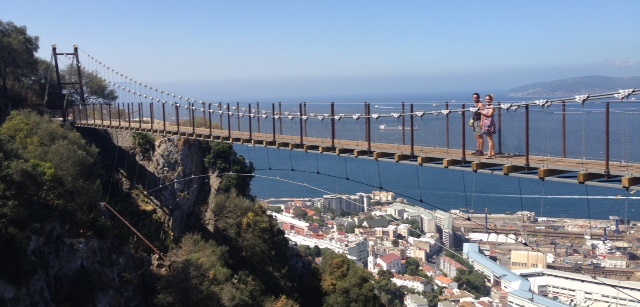
. . . At dusk, when Janet Gwynn first set eyes on the Rock of Gibraltar from the deck of the HMS Cormorant, it reminded her of a supernatural fortress, its peaks rising like towers above an immense jagged hump. Fourteen hundred feet, they told her, but up close it seemed much higher.

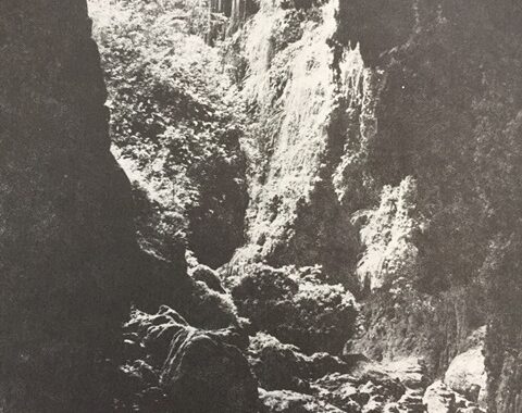
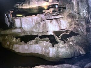
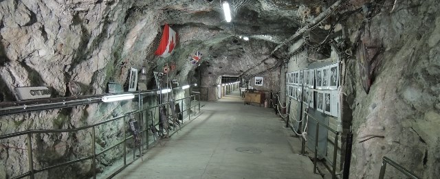
A soldier hustled Janet and several other nurses off the ship and into a rough-hewn gray tunnel lit by dim electric bulbs. The interior of the Rock held a maze of tunnels, more than thirty miles of them, according to the soldier, carved out of the soft limestone from north to south and east to west. Janet turned and soaked in the receding circle of blue sky at the tunnel entrance. Who knew when she would she enjoy sunny skies again . . .

They followed the soldier through numerous tunnels, identified by names of English streets. Some were wide enough for vehicles, he explained, while others served as bunkers for weapons and supplies, or were reinforced with half-cylindrical Nissen huts to hold offices, workshops, a hospital ward, mess halls, and sleeping quarters. “Also a water distillation plant, generating station, and frozen food storage. We can sustain 1,600 soldiers for up to 16 months.” He expected, and received, the nurses’ awe.

Their sleeping quarters, a grey room with bunkbeds and small chests of drawers, adjoined the hospital ward. “As soon as you settle,” the soldier told them, “they need you in there. Survivors of a ship blown up in the strait last night.”

Soldiers in various stages of injury were being cared for by one doctor and three nurses. For three hours, with scarcely time to breathe, Janet tended to broken arms and legs, applied compresses on burns, and offered comfort to young men screaming in pain and fear. When Dr. Rudolph asked for someone to get more bandages and syringes from a supply room, she gladly volunteered.

He rattled off a litany of street names interspersed with right and left turns that would take her to the supplies. “Got it?”

“Yes, sir.”

But she hadn’t. Almost immediately, she encountered tunnels with unfamiliar names, and crossroads that offered too many choices. Before long, she was lost, hopelessly lost, in what seemed to be a remote section of the labyrinth.

Janet noticed a room with a metal door ajar. Hoping it would be an office with a telephone, she entered and made her way down a long hallway.

Suddenly, she heard the sound of a faraway click. The hallway plunged into blackness, followed by the screeching sound of a metal door being shut. Paralyzed with fear, Janet could only scream for help. In answer, silence pulsed around her, darkness pressed in.

For what seemed an eternity, and was actually two days, she sat in the blackness, her stomach empty, her throat parched. Periodically, she let out a shout that sounded like a dying car horn. She thought of her parents, her younger brother, the beau she left behind. What a terrible way to die.

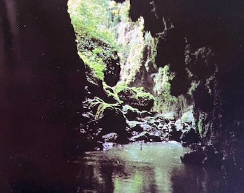
When all seemed lost, a brilliant shaft of light pierced the blackness, illuminating the silhouette of a soldier. He stepped in.

“Help,” she croaked.

“Criminy! I thought I’d heard a bird.” A light clicked on. Shielding her eyes from the bulb, she looked up at a handsome young man, smartly dressed in a Canadian uniform. The name engraved on his pocket was Gareth McMurray.

She spent the next two days recovering in the hospital ward. Though she asked repeatedly, no one seemed to know of the hallway with the metal door. Periodically, she would look for it, but it seemed to have vanished.

Janet served with distinction during the war. When it was over, she and Gareth married and moved to Canada. Decades later, he told her of Operation Tracer, a top-secret project to establish an observation post that would continue to function – sealing six volunteers inside the cave – in the event Nazis captured Gibraltar. During a pause in construction, a careless engineer had left the entrance door open and, after Janet stumbled in, returned to close it. When Gareth, also part of the project, was taking exercise in the tunnels, he heard what he thought were bird cries and went to investigate.

**

Nanny pressed her hands together against her chest. “And that’s how your grandfather saved my life.”

The Place: Gibraltar

The Mediterranean is vast—almost a million square miles of sea that extends 2,400 miles from east to west. Yet at its eastern edge it narrows to a mere nine miles known as the Strait of Gibraltar. To the north, on a small peninsula connected to southern Spain, a large limestone rock rises some 1,400 feet above sea level and resembles a great leviathan with a ragged, razor-thin spine. Regarded by the ancients as one of the Pillars of Hercules marking the edge of the known world, Gibraltar is a fabled spit of land, long haggled over by Spain and Great Britain. Although a Spanish friend of mine vowed his undying wrath if I ever stepped foot on Gibraltar, the British territory has long fascinated me as a gateway to different cultures that somehow coexist on one of the most densely populated places on Earth. Thus, my virtual journey to Gibraltar.

Gibraltar [Ayala, Wikipedia Commons]

In Paleo times:

A series of caves pock the Rock’s limestone walls at sea level on the steep southeastern side of the peninsula. Fifty to a hundred thousand years ago, during an icy age of lower sea levels, the caves lay some three miles inland and were inhabited by Neanderthals, who hunted on the coastal plain and in the sea, fashioned tools, and left rock engravings.  One of the last refuges for Neanderthals in Europe, Gorham’s Cave Complex is today a World Heritage Site. 

Gorham’s Cave Complex [Gibmetal77, Wikipedia Commons]

Moorish history in a name:

The word ‘Gilbraltar’ derives from the Arabic Jabal Tarik (Mount Tarik) in honor of a North African commander who landed on Gibraltar in 711 and went on to conquer the rest of the Iberian Peninsula. This began 750 years of Moorish rule in Spain. Remnants of that period on Gibraltar include fortifications, walls and towers, mosques and Moorish baths, and cuisine.

Of wars and shipping:

By the late 1400s Spain’s Christian kingdoms had defeated the Moors. Soon afterward on Gibraltar, a mosque near the southern tip was converted into a chapel and renamed the Shrine of Our Lady of Europe, still in use today. In the early 1700s war broke out over who would succeed the heirless king in Spain. Afterward, Gibraltar was ceded to Great Britain. Later in the century, Spain and France tried to retake the Rock, and the British excavated what are known as the Great Siege Tunnels. The siege failed. With the opening of the Suez Canal in the late 1800s Gibraltar became an important stop for trade ships. During World War II, it served as a base for the North African campaign, and the tunnels were expanded.

People, people, almost everywhere:

Today, some 34,000 people live in Gibraltar’s two-and-a-half square miles, and upwards of twelve million visit every year—this year of course being an exception. To relieve the crowded conditions, projects have reclaimed some land from the sea. The territory is a melting pot of British, Spanish, Moorish, Jewish, Maltese, Genoese, Indian, and Portuguese cultures. English is the official language and Llanito, Andalusian Spanish mixed with English words, the local vernacular. The older architecture is equally diverse and includes museums and historic gardens. On the western plain, modern highrises, marinas, casinos, promenades, hotels, shops and restaurants cater to residents and visitors alike.  One road connects Gibraltar with Spain, and the wait to cross the border can be painfully long.

Monkeys and other curiosities:

Barbary macaque [Needpix.com]

The steep slopes of the Rock have discouraged development and today are protected in Gibraltar’s Upper Rock Nature Reserve. A couple of roads, primarily for tour drivers, crisscross the mount, and a cable car connects the city with one of the highest points. A number of sites up here definitely merit a visit. Several hundred tailless Barbary macaques (monkeys), concentrated at Apes Den, live on the Rock. Originally from Morocco’s Atlas Mountains, they are Europe’s only wild monkey population and, according to local legend, as long as they exist on Gibraltar, the territory will remain British. During World War II, Winston Churchill augmented the population with North African immigrants, just to be on the safe side.

A series of extensive caverns known as Saint Michael’s Cave has been known since ancient times and has sheltered inhabitants as far back as the Neanderthals. A large upper portion, Cathedral Cave, today hosts a multi-colored light show and houses an auditorium with excellent acoustics. A recently discovered lower cave (closed during the Coronavirus) leads down to an eerie underground lake. On the northwestern flanks of the rock, a fortification known as the Moorish Castle dates back to Arab times, and its box-shaped Tower of Homage remains a popular landmark.

Windsor Suspension Bridge [visitgibraltar.gi]

For those without a fear of heights who crave spectacular views, the Mediterranean Steps links Jews’ Gate Cemetery with British batteries and the summit. Recently inaugurated, the Windsor Suspension Bridge spans a 150-foot gorge overlooking the city, and the Skywalk, perched on a skinny ridge atop a World War II lookout, consists of a transparent glass platform and walkway. Not for the faint of heart!

To take your own virtual tour of Gibraltar, log onto the following websites—https://gibraltar.com/and https://www.visitgibraltar.gi/

The Story: The Everglades

Author’s note: To get the most out of this story, I recommend you first read the previous blog about the place. Thanks!

The moment ten-year-old Opal Pagenet saw a photograph of bald cypress trees in the Everglades—a double spread in National Geographic – she fell in love with the skirted trees perched in inky water. They stirred in her something magical.

With her mother’s help, she sliced the picture out of the magazine and tacked it on a bulletin board in her room, where it remained throughout her school years, ready to transport her to the faraway place at a moment’s notice.

Every summer, she begged her parents to take the family – Opal and her two brothers – to the Everglades, and every summer they refused.

“It’s too far to drive from Indiana,” her father pointed out, “and besides, summer isn’t the time to visit southern Florida. It’s hot and muggy.”

“A sauna,” her mother concurred. “Winter would be lovely. That’s when the rich people go.” Left hanging was the inference the Pagenets weren’t rich.

The years went by, and Opal graduated from high school. In the summer before college, she worked in the office of a construction company until mid-August. That left her with two weeks of holiday time. She planned to spend it in the Everglades.

Her parents nixed the idea, only relenting when her older brother Bill volunteered to go with her. “I’m sick of hearing about those trees,” he grumbled. “I’ll go if you promise never to mention them again.”

A long bus ride got them to Miami. Stepping off, Opal felt heat so thick it made her dizzy. She looked at Bill. Sweat coalesced in droplets on his face and neck. “Whoa,” he said.

After a night in an air-conditioned motel room, they set out the next morning in a half-filled tour bus. Opal wore the items she’d bought expressly for the trip – a floppy hat, short-sleeved shirt, khaki shorts, and hiking sandals. Bill wore jeans, a T-shirt, and sneakers. Both carried backpacks with water bottles, snacks, sunscreen, and mosquito repellent – all as of yet untouched.

The driver stopped at a site he promised ideal for viewing bald cypress trees. “This time of year they look awfully pretty, surrounded by water from the summer rains. Awfully pretty, if you can stand . . .” He left the sentence unfinished. “Remember, last bus at 6:00. Don’t miss it,” he warned.

Outside, the sun throttled them, and muggy heat wrapped them in a steamy cocoon. Opal found it hard to breathe and wished, in vain, for a breeze.

A boardwalk stretched across water to a gathering of bald cypress. She sucked in her breath. The trees stood tall and straight, scattered randomly several feet apart.  Pleated buttresses fanned into water so still it created a mirror image of each tree. Bouquets of plants clung to the trunks, and birds flitted from branch to branch. Sparse needle-shaped leaves dappled the sunlit water with shadows.

At last . . . Opal dashed along the boardwalk. So engrossed in the setting, she didn’t notice a prickly feeling on her skin until it was way too late. When she looked down, her bare arms and legs were blackened masses of writhing, bloodsucking mosquitoes. With a cry of distress, she jerked around in a frenzied dance, attempting to dislodge the bugs. They only sucked deeper, and others joined the fray.  Swatting wildly with both hands, Opal couldn’t even get the backpack off, much less open it, pull out the repellent, and spray it on. “Bill, help!”

But Bill was doing his own crazy dance. The mosquitoes appeared to be swarming an inch thick about their heads, arms, and legs. Opal’s swatting plastered a hundred dead bugs to her skin, but thousands upon thousands remained, mini-vampires zooming in for the bite.

Slipping off her backpack, she jumped into the water. It was waist deep. Taking a breath and closing her eyes, she submerged until only her hat floated on the water. They’re gone . .  . But of course she had to surface. When she did, a family came running toward her on the boardwalk.

“Alligators!” the father shouted.

Terrified, Opal struggled to get out. “Where?”

“I don’t see any, but this water is full of them.”

At that moment, a forest ranger strode toward her. “Out of there!” he shouted. “No swimming permitted.”

“I’m not swimming! I’m being attacked by a gazillion mosquitoes.”

The ranger extended his hand and pulled her up onto the boardwalk. He looked at her backpack. “Don’t you have spray?”

“I didn’t have time to get it out.” Everything she said ended an octave higher. The mosquitoes were returning with a vengeance.

The ranger found the repellant in Opal’s pack and sprayed it on her, then turned to Bill and sprayed him, too. The buggy hordes dispersed.

“What were you thinking? Mosquitoes aren’t bad in the winter, but in the summer . . .” His ranger hat wagged. “And this summer we’ve had more rain than usual, which means a bumper crop of bugs.” He looked at her skin. “They also love fresh flesh. Didn’t your tour driver tell you any of this?”

Bill and Opal exchanged perplexed looks.

Back at the motel, Opal and Bill took turns bathing in cold water and slathered their skin with calamine lotion, then slipped under the sheets of their beds so they wouldn’t be tempted to scratch.

“Well,” Bill said, “I guess this has cured you of those damn trees.”

Opal looked at him and smiled. “Not at all. I just plan to get rich so I can come here in the winter.”

The Place: The Everglades

Many of the scientists I knew who worked at El Yunque National Forest in Puerto Rico spoke with reverence about the Everglades of southern Florida, one of the world’s premier sub-tropical ecosystems. They also spoke with alarm as human development in the region expanded, shrinking the ecosystem and reducing its water supply. Recently, I decided to make one of my life-in-the-time-of-coronavirus virtual visits to Everglades National Park.  Most surprisingly, I learned that my original vision – a monotonous expanse of low-lying scrub and meandering waterways — was inaccurate. In reality, there are several very distinct habitats found in the Everglades.

This image has an empty alt attribute; its file name is everglades-nps-5-1.jpg

Grassy marshland, courtesy National Park Service

What’s in a name?

When early explorers first viewed this region long ago, they were impressed with its vast fields of marshland grass. As a result, they combined the word ‘ever,’ a shortened form of ‘forever,’ with ‘glade,’ an old-fashioned English word for a grassy open place. The name stuck. Of course, the native Americans who lived here had their own name — Pa-hay-Okee, which translates into ‘grassy waters.’ The grasses are found primarily in freshwater sloughs and swampy prairies. The word ‘slough,’ meaning a marshy wetland, rhymes either with ‘cow’ or ‘stew,’ depending on your preference. The water for the wetlands slowly meanders south from Lake Okeechobee, which is exceedingly large, approximately 720 square miles, and exceptionally shallow, with an average depth of nine feet. The most prominent grass, sawgrass, is actually a sedge, with sawlike teeth along the blades. There are also dozens of species of true grasses, and the height of the grasses rarely reach four feet.

Standing tall(er):

This image has an empty alt attribute; its file name is everglades-flickr-4-1.jpg

Bald cypress trees, courtesy Flickr

Trees also grow in the Everglades, on patches of land that suit their ecological fancies, primarily slightly higher and dryer limestone. Here, straggly pines tower over saw palmettos, which remind me of palm trees without trunks. The fan-shaped leaves have sawlike edges, and an extract from the palm is touted as a panacea for prostate problems. You’ll also find more majestic hardwoods, such as mahogany, gumbo limbo, oak, and maple. Perhaps most haunting of the tall trees here are the cypress. Conifers that shed their leaves, cypress are water-tolerant, found along the Everglade waterways and marshy craterlike formations. With their skirtlike buttresses dropping into inky water, they resemble ladies on a stroll.

Walking into the sea:

This image has an empty alt attribute; its file name is everglades-wc-3-1.jpg

Mangroves, courtesy National Park Service

Along the coastal tip of southern Florida, mangroves mark the first line of defense between the often-turbulent ocean and inland freshwater. Three hardy species of mangrove – red, black, and white – tolerate not only water but also salt and wind. Their stilt-like roots form intricate networks that anchor the mangroves to the ground, and ‘walk’ by growing new roots into the sea. Beyond them, between the coast and the Florida Keys, lies Florida Bay. Comprising almost a third of the national park, these shallow waters make for excellent fishing, but, like all of the Everglades, suffer from a myriad of ecological problems.

Getting around:

The Everglades National Park is huge, 1.5 million acres, and much of it is remote and inaccessible. Getting around is a challenge. No highway crisscrosses the entire park, and you gain access through three separate entrances hours apart. The ones near Miami (Shark Valley) and Homestead (Main Entrance) lead you into the heart of the park while the third in Everglades City enables you to explore the mangroves and Thousand Islands of Florida’s Gulf Coast. Here are nature trails, hiking and biking trails, boat and tram tours, canoeing and kayaking waterways, campgrounds—all of which can introduce you to the creatures of the Everglades – manatees, sea turtles, panthers, pythons, alligators, and a multitude of fish and birds. But beware – it’s best to go in winter, when the temperatures are relatively cool and the mosquitoes at bay.

Odum's 1960s Everglades Studies Shape The Science of Ecology (U.S. ...

Courtesy National Park Service

Next week — the story.

The Story: Crater Lake

Author’s note: To get the most out of this story, I recommend you first read the previous blog about the place. Thanks!

Author’s note: This story is historical fiction. Though reworked, most of it is true, thanks to information found at the Crater Lake InstituteMail TribuneOregon Encyclopedia, and Wikipedia.

Many people know of William Gladstone Steel as the man who spent seventeen years cajoling the powers-that-be into designating Crater Lake as a National Park. Some know he came from a family of abolitionists active in the Underground Railroad. Few know that Will was a dreamer and a mystic, and that his life was shaped by the occasional haunting magical moment.

When a schoolboy in Kansas, Will first learned of Crater Lake. Unwrapping the newspaper that contained his lunch, his gaze fell upon an article about an explorer’s discovery of a caldera-rimmed lake in Oregon. The explorer waxed euphoric over the deep-blue color of the water. Such a random encounter—if his mother had wrapped the lunch differently, the boy may never have seen the article. He vowed to visit the lake one day.

As chance would have it, in 1872 the Steel family moved to Portland, Oregon, where Will completed high school. Several years after his father died, he had a dream. In it, he and his father were wandering the narrow streets of an ancient city. “Will, do you wish to see something beautiful?” his father asked, then pointed upward, to golden arrows piercing the sky. “This is Cleetwood,” his father said, just before Will woke up. Though the word meant nothing to him, it conjured up a lovely memory, and he kept ‘Cleetwood’ close to his heart.

When Will finally reached the lake, in 1885, the gemlike deep blue water dazzled him. He longed to row across it but had no boat. The following year he joined Captain Clarence Dutton’s geological expedition to Crater Lake. His job—to provide wooden boats and depth-sounding gear. The largest boat he christened the Cleetwood. In mid-July, the expedition arrived at the rim of the lake. With great effort, several mishaps, and a near catastrophe or two, they lowered the boats down some eight hundred feet of a steep volcanic slope made more treacherous by fine-grained pumice. It took fifteen men eight hours to lower the twenty-six-foot-long Cleetwood, encased in a crate and set atop a sled. Their embarkation site was a small cove that would later bear the boat’s name.

The expedition remained for three weeks, examining the caldera and the lake and measuring its astounding depth. Will longed to have time alone on the lake. One night, when the moon was full, he stole away from camp and took a boat across the water. Later, he would write, “There was not a breath of air stirring and reflections were as perfect as it could have been in a plate-glass mirror. The walls were clearly outlined above the water and below were inverted, but just as clear. Upon yonder a full moon floated in the air and down below it was just as clear and beautiful. … I was an atom in the center of an enormous sphere, looking up to the starry heavens and looking down at its counterpart. The shoreline and its reflection appeared as a great knothole, with creation above, the creation below. … God in His infinite mercy permitted me to look out upon His glorious works as never man did before.”

At the end of their scientific work, the men agreed they could not get the boats back up to the rim, nor could they leave them to be vandalized or misused. So they scuttled them to the bottom of the lake, two thousand feet below.

Will dreamed the boats would lie there until Congress made the lake a national park. “Then,” he proclaimed, “the resurrection trumpet will sound, and the Cleetwood will awake. So must it be!”

The Place: Crater Lake, Oregon

Before the advent of the Internet, one of my most often used reference books was Roget’s Thesaurus. When I wanted to find the perfect synonym, I would look up the word and flip to the related site for dozens of similar words from which to choose. Today, I picked up the old thesaurus and searched for ‘blue.’ Under the blueness site I found all sorts of possibilities for a deep blue – azure, delft blue, cobalt, Turnbull’s blue, navy, midnight blue, indigo, ultramarine, sapphire blue, lapis lazuli blue. Why the search? All those shades and more can be seen, at different times of day and seasons of the year, in the waters of Crater Lake, Oregon.

BF3CA15B-E0AE-4829-AC9B-256084B701E2

What causes the lake’s intense blue?

To answer the question, we must go back in time, millions of years, when two immense slabs of rock known as plates, one under the Pacific, the other under North America, collided. Over vast amounts of time, the collisions formed a string of volcanoes along today’s Cascade Range. One of these volcanoes is Mount Mazama. Occasionally the volcanoes erupt, as happened with Mount St. Helens fifty years ago. Almost 8,000 years ago Mount Mazama erupted. [Tribes who inhabited the region at the time witnessed the event, and it has become part of the Klamath Tribe’s oral history.]

59D691E7-B9CD-4981-825E-8EA9E7DE3676

The top of Mount Mazama collapsed, forming a deep craterlike caldera. Located some 6,000 feet above sea level, the mountain gets rain and more than 43 feet of snow every year. Over the millennia, the rain and snow have fallen into the caldera, filling it up to become, at almost 2,000 feet, the deepest lake in the United States. No rivers, thus no sediments, flow into or out of the lake, resulting in some of the purest water in the world. Because of the depth and clarity, sunlight can penetrate deep into the lake, absorbing longer rays on the light spectrum and reflecting shorter rays, which consist of the violet/blue hues. And that is why the lake appears so blue.

The caldera:

The caldera averages five miles in diameter, forming an almost perfect circle. Several cones poke up in the center, but only one, Wizard Island, rises above the water. The rim itself is jagged and uneven, towering almost 2000 feet above the lake in some places, 500 feet in others. The rock and pumice are of volcanic origin and give the rim a chalky gray appearance. Scatterings of pine trees grow on the less precipitous slopes as well as on Wizard Island. A road, open only in the summer, circles the lake, and there are many pullouts to park and take in the spectacular views. Unfortunately, the road can become congested, with jostling for available parking spaces. For those who want to touch the water, there is one trail. Located opposite Rim Village Visitor Center, it descends to Cleetwood Cove, where you can fish, swim in the chilly water (some 57 degrees F.), and take a boat to Wizard Island. The trail is short, scarcely over a mile one way, but it is steep and strenuous, dropping some 700 feet in switchbacks. It is not for the faint of heart or knees.

Sunlight is best:

846B8D6A-BE92-4532-90F9-4CEE2DA71268

Proof I was there — the second visit

I’ve visited Crater Lake twice.  The first time was in early summer. The road to the lake didn’t seem precipitous, so it came as a surprise to see big drifts of snow everywhere. Clouds hovered overhead and rain, or perhaps sleet, threatened. The scale of the lake was spectacularly grand, but I had to use a lot of imagination to conjure up its indigo splendor. On my second visit, the day was sunny with mere wisps of clouds, and the water dazzled. It looked as if trillions of sapphires, lapis lazulis, and other deep-blue gems had been mixed and melted and spread from rim to rim. With luck and good health, I hope on my third visit to get to down to the lake, take the boat ride, and immerse my body ever so briefly in the pure water. However, it won’t be in 2020 as the boat tours have been cancelled due to the coronavirus.

Anything else?

6E9D64A3-15D7-40EF-922F-61194F1AE49B

View across the park in July

Though most visitors make a beeline to the lake, Crater Lake National Park actually encompasses over 180,000 acres. Roads lead to Pinnacle Valley, which resembles a forest of gray pine trees, and through the Pumice Desert. Trails take hikers to many peaks and points and a sphagnum bog. The Pacific Crest Trail cuts through the park from north to south, with an alternate section for Crest hikers who want to see the lake. There are many opportunities for biking and backpacking, and the park remains open for winter sports, accessible from the southern and western entrances.

The Story: Río Camuy Caves

Author’s note: To get the most out of this story, I recommend you first read the previous blog about the place. Thanks!

“Are we good to go?”

The guide squinted one eye shut. From the other, he scanned Martin Hennessey from head to foot. Helmet with attached lamp. High-quality life jacket. Overstuffed nylon backpack. Fast-drying short-sleeved shirt and pants. Leather and air-mesh hiking boots. He pursed his lips.

“We’re good.” Martin voiced confidence, but he had the uneasy feeling Emilio was focusing more on his stomach paunch and flabby arms than his equipment. A year of strenuous exercise couldn’t quite erase ten years of sitting behind a desk.

Except for a tattered life jacket, Emilio’s attire resembled that of a miner more than a caver—badly dinged helmet with carbide lamp, well-worn Levi jeans, heavily stained button-down cotton shirt, steel-toed boots.

The two stood at the rim of an immense sinkhole. Next to their feet, a narrow path descended steeply through trees and shrubs that clung tenaciously to rocky soil. Elsewhere, the cliffs dropped vertically, and only lichens and tufts of grasses broke through the gray limestone rock. At the bottom, some 200 feet below, tropical forest grew in chaotic abundance everywhere but the jagged cave entrance on the far side. It resembled a shark’s mouth open in anticipation of its next meal.

Pues, vámonos.”

Martin sprang down the path. Almost immediately he lost his balance and had to grab for the nearest spindly tree trunk, which was covered in tiny thorns. “Damn!”

Emilio caught up with him. “Please, let me take the lead.” He inched his way around Martin and eyed the red pinpricks on his hand. “Perhaps you should put on your gloves.”

With slow, careful steps, they made their way to the bottom of the sinkhole and followed a path through a tangle of greenery along the crater floor. When they reached the cave entrance, Emilio eased his backpack onto the ground and sat on a nearby rock. Martin did the same.

In front of them, the cave rose more than seventy feet along the cliff wall. Vines and ferns dripped like drool from stalactite teeth. On the inside, Martin could barely make out the leaden outlines of large boulders on either side of a river before the cave erased even that. Beyond was blackness.

The Camuy would be the fifth major cave system Martin had explored in the space of a year, enough of an accomplishment to merit a short article in the NSS News of the National Speleological Society.

So there, Christine. He’d made sure his former wife received a copy.

Like many men blindsided by a failed marriage, Martin had taken up extreme sport adventures to prove he was doing just fine, thank-you-very-much. While most took to climbing peaks or trekking across continents, Martin gravitated to the Earth’s basement.

The Camuy Caves sheltered what many cavers considered the most beautiful rimstone pool formation in the world. Intricate terraces of scalloped calcite pools descended in levels down the rocks. The water within them gave off a dim bluish glow. The pools were as remote as they were beautiful. Very few cavers had seen them, giving the Camuy formation a mythical renown. “Find it,” the editor of NSS News told him, “bring back photographs, and I’ll feature you in a cover article.”

Standing, Martin adjusted the pack on his back. “Let’s get started.”

The Place: Río Camuy Caves, Puerto Rico

The Río Camuy is one of dozens of rivers that get their start in Puerto Rico’s rugged Cordillera Central. What makes the northward-flowing Camuy different is this: at one point it vanishes into a cave entrance known as the Blue Hole, tumbles through a vast collection of underground caverns, falls, tunnels, lakes, and chasms, then resurfaces some four miles farther north and continues on its journey to the sea

Big:

Formed over the eons by water dissolving the region’s porous limestone, the Camuy is big—one of the largest cave and underground river systems in the world. Some ten miles of cave networks and more than 200 individual caves and a dozen entrances have been probed and plotted. Experts believe much more remains to be discovered. One of the caves, aptly named the Big Room, is 200 feet high and 600 feet long. Most of the entrances are sinkholes, craterlike depressions formed when cave ceilings collapse, and these too number among the largest in the hemisphere. Camuy’s largest, Tres Pueblos, could hold one and a third baseball fields. Instead, it holds a lush tangle of tropical vegetation and the remnants of an old banana farm.

In the past:

Taino Indians, believing the human race originated in caves, considered them sacred and ceremonial. They used the Camuy for water supplies, carved petroglyphs on walls, and explored, probably with torches, up to areas of deep water or steep drops. While local residents had always been aware of cave-pocked sinkholes in their backyards, the Camuy Caves remained largely unexplored until the late 1950s, when an internationally known caver named Russell Gurnee and a group of local cavers began to systematically explore the system, eventually thrusting the Camuy into the speleological limelight.

Before and after:

img_2429

Entering a cave

When I first glimpsed a shadowy cave entrance from the rim of Tres Pueblos Sinkhole in the early 1980s, the Camuy, though known to speleologists, remained little known to the public-at-large. I was fortunate to be able to explore several small portions of the system. On my debut trip, I went with members of the Speleological Society of Puerto Rico. Prepared with hard hats, life jackets, and three light sources, we descended the sinkhole and passed through a long toothy mouth of blackened rock. Once inside, we swam up narrow canyons and across small lakes, then, soaking wet, climbed up, down, and over slopes, precipices, and rocks. In the flickering light, I felt like part of a primeval religious procession; when we turned off the flashlights, we were surrounded by stunning silent blackness. We passed the cathedral beauty of a second sinkhole, the immense Big Room, a disorienting bridge of boulders, and scalloped rimstone pools, which seemed the exquisite abode of elves and fairies. The caves actually house more mundane creatures — dozens of insect species and millions of bats.

In 1987, the Puerto Rican government opened the Parque Nacional de las Cavernas del Río Camuy (Río Camuy Cave Park). By tram and on foot, the public can descend into a lush sinkhole, tour a penumbral cave with beautifully lit stalactites and stalagmites, and look down at the river below. The tours have been immensely popular, enabling hundreds of thousands to view the caves.

If you go:

Due to the caves’ fragile nature, the park has often closed over the years. It closed after Hurricane María and is undoubtedly closed for the coronavirus. Check before you go. If you do go, plan to get there early to ensure a tour. There are also groups that will take you caving through portions of the park. Research your group well. With potential flash flooding and other dangers, you want a group that will make your exploration memorable . . . in a good way!

The Story: Anza-Borrego Desert

Author’s note: To get the most out of this story, I recommend you first read the previous blog about the place. Thanks!

1958: Dan Lanyard trudged up a remote Anza-Borrego hill. Though long past midnight, the moon was full, the sky, clear. He could easily make his way around boulders, scrub bushes, and cacti spread across the sand, even with all the beer and whisky that jostled in his stomach. Beyond one exceptionally large boulder, his house came into view.

Well, it wasn’t exactly his house. It was a place he’d stumbled upon several years earlier in his desert travels. Quite small, it had thick adobe walls, a corrugated metal roof, and large windows, the panes missing or cracked. Inside, a dilapidated sofa and wooden rocking chair remained from the previous occupant, but a thick layer of dust everywhere indicated that person was long gone. Dan tossed his sleeping bag on the floor and returned to the house whenever he was in the desert. A year ago, he moved in full time. With Myra.

Though Dan loved the desert, with its purifying heat and views unsullied by humidity or pollution, that wasn’t the main reason he explored its nooks and crannies. He descended from a long line of dreamers and schemers. Dan’s dream involved finding gold in the Anza-Borrego hills.

After all, a century earlier the explorer Pegleg Smith had found gold—solid nuggets—in the surrounding hills. The site had never been exploited, not even by Smith himself, who had to flee the region before he could do so. But he’d drawn maps of the mine’s location . . . Finding one of those maps would mean finding the site, of that Dan was certain.

His one nod to civilization was a monthly visit to the Last Chance Bar in the small town of Borrego Springs, a seven-mile walk from the house. At the bar, he met Myra, and it was she who convinced him to move full-time to the desert.

Both of them were refugees from metropolitan Los Angeles. Myra, a plain woman with undersized eyes and an oversized nose, combed the desert for the lovely remains of Native American pottery. “If we’re here all the time,” she reasoned, “we have greater chances of finding what we’re looking for.”

They fixed up the place as best they could. Myra decorated with new-found pottery and dried sprigs of wildflowers. Dan tacked up a tarp against the front of the house for shade, and they found two folding chairs in town to go beneath it. They survived off beans, seeds, and nuts, and pulled water in five-gallon containers up the hill on a makeshift cart. Before dawn, each took off on their own separate searches for the treasures of the desert; by night, they sat in the folding chairs, counting stars in a black sky.

Dan had forgotten how nice it was to live in the company of another person, which was why a part of him couldn’t believe what he’d done tonight at the Last Chance. He and Myra had brought their savings with them to the bar, a hundred dollars, primarily earned through the sale of Myra’s Native American pottery. The plan was to stay overnight in town, then make their way to Los Angeles, where they would spend a month visiting family and enjoying the comforts of civilization.

Halfway through the evening, a leathery stranger sat down next to Dan. Leaning close, he spoke in a whisper. “I hear you’re interested in Pegleg’s map.”

Though he feigned nonchalance, Dan stiffened with excitement. “I’ve come to wonder if it ain’t just a myth.”

The stranger puckered his wrinkled face. “Myth? Then what’s this?” He pulled a yellowed, oft-folded, stained document from a shirt pocket and opened it up, being careful to keep it from Myra’s view. There it was, a map of Ghost Mountain, with drawings of landmarks, a dotted line and an x, and minute annotations on the side. “I’m only offering it to you ‘cause I hear you’re a bonafide prospector.”

Dan’s heart knocked against his ribcage. “How much?”

“Ninety-nine dollars.”

After the stranger left and Dan could hide his excitement no longer, he confessed to Myra what he’d done. She responded by slapping him in the face and stomping out of the bar, but not before she shouted out for everyone to hear, “You’re a self-centered dimwit! I never want to see you again.”

Once he reached the house, Dan sat in one of the two folding chairs, pulled the map from his pant pocket and unfolded it. Pegleg Smith’s map—signed by the man himself. At long last. Yet somehow having it in his possession didn’t thrill him the way he thought it would, and he had to shrug off dark thoughts that it might just be a piece of paper.

The Place: Anza-Borrego Desert, California

My fascination with the Anza-Borrego Desert began years ago, when my husband and older daughter (then a baby; now a mother herself) camped there overnight, enjoying spectacular carpets of colorful spring flowers during the day and pinpricks of stars against a black sky at night. Today, Anza-Borrego is officially designated as an International Dark Sky Park and traffic clogs the roads when the flowers are in bloom, but for the most part it remains a place of secluded desert beauty.

DD70A48E-9298-4D8E-B05E-B50C520C5925

The desert in winter

What’s in a name?

Largest state park in California, Anza-Borrego couples the region’s history and natural resources in its name. The Spanish explorer Juan Bautista de Anza lived in Mexico and took up his father’s crusade for a land route to the Spanish settlements on the west coast, leading an expedition across the desert in the 1770s. And borrego, Spanish word for a young lamb or sheep, refers to the desert’s iconic bighorn sheep, known for their large curved horns and sure-footedness on steep mountain slopes.

Of mountains and badlands:

46FD28A2-50FB-48C8-8575-DA4542F60EF3

Borrego Badlands

Millions of years ago, the region alternated between being underwater, flooded by ancient seas, and above water in a lush environment similar to that of today’s Caribbean. At the same time, southern California went through cataclysmic geological movements that produced today’s mountains and valleys. In recent times, water and wind eroded down what nature had thrust up. As the region became drier, plant life became scarcer, laying bare ageless geological formations — ridges, ravines, canyons, caves, sandstone sculptures, dry washes and lake beds — all brushed with earth-tone hues. Most impressive are Anza-Borrego’s badlands, byzantine mazes of extensively eroded terrain that resemble the Grand Canyon in miniature. Trails and rugged tracks lead around and about the formations.

Summer heat – curse or blessing?

Highways22view

Highway S-22 [Wikipedia Commons]

Several years after our first visit, we were traveling with our two young daughters in California during the summer and decided to detour to Borrego Springs, the small town in the heart of Anza-Borrego. From the heights of the San Isidro Mountains to the west, we looked down on a spectacular sun-drenched landscape. At that point, Highway S-22 quickly descends some 3,500 feet along the winding Montezuma Grade to reach the valley floor. We went from a cooler to an oven. At our motel, the swimming pool water steamed and the outer doorknob to our room sizzled. We had to rise while still dark to take a walk before the sun fired up. It was a detour that evoked huge complaints at the time but has transformed over the years into a cherished family memory. Well, sort of.

The desert floor is, for most people, unbearably hot in the summer. The average high temperatures from June through September hover above 100 degrees F. This eliminates all but the hardiest – some 3,500 residents – from relocating on the private land in the heart of the state park and transforming it into another suburb of San Diego. Over the years, Anza-Borrego has attracted its share of eccentrics,  mostly notably gold miners and desert ascetics.


Borrego Springs:

ECB084C3-E47B-4935-BEBB-36FAC4FC6E65

Borrego Springs remains a pleasantly quirky, spread-out town of small shops and galleries, streets with names like Christmas Circle and Frying Pan Road, and over a hundred larger-than-life metal sculptures of prehistoric and fantastical creatures created by Ricardo Breceda. For the winter snowbirds, the town has resorts, restaurants, campgrounds, golf courses, and, of course, the state park with a lovely visitors’ center. Of all the trails in the park, the most popular one follows Borrego Palm Canyon, a rare place of moist soil that shelters a number of fan palms, California’s only native palm. Clusters of green fronds rise above older leaves on a trunk that resembles an old man’s beard.

And every day there’s the promise of unforgettable sunrises and sunsets.