The Story: The Dead Sea


 Author’s note: To get the most out of this story, I recommend you first read the previous blog about the place. Thanks!

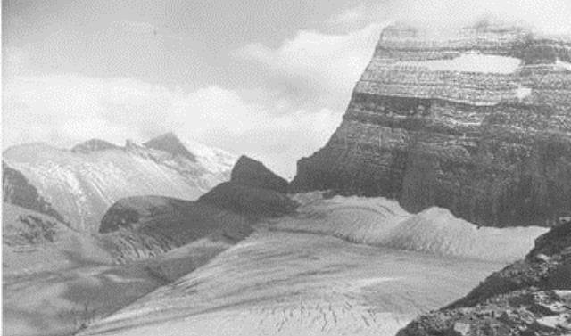
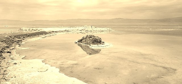
The Jordan River Valley around the Dead Sea provides the setting for one the more curious Biblical stories, that of Lot and his wife’s transformation into a pillar of salt (Genesis, chapters 11-14, 18-19).

The story begins when Lot’s father dies, and the young man joins his uncle, Abram, later known as Abraham, and Abraham’s wife Sarah on a journey. God has called on Abraham to leave his country and settle in Canaan (the region of today’s Israel), where he will make Abraham’s people into a great nation. They reach Canaan and establish a settlement.

Here we have a puzzling footnote in our story. A famine soon ravages the region, and the three leave for Egypt. There, Abraham pretends Sarah is his sister. He reasons thus: Sarah is beautiful and, if the pharaoh sees her, he will kill Abraham and take Sarah as his wife, and Abraham needs to live. Well, the pharaoh does take Sarah as his wife, but God causes a series of plagues to befall Egypt. Abraham confesses the truth, and he, Lot, and Sarah are thrown out of Egypt—curiously, with all their possessions.

After this, Lot and Abraham return to the area of Canaan where they had settled earlier. However, because the land cannot support both men’s vast flocks and herds of livestock and the herdsman are beginning to quarrel, they decide to separate. Lot heads east to the rich plains of Jordan, pitching his tents near the town of Sodom.

Not a good idea. The people of Sodom are known to be wicked, morally corrupt sinners against God. At one point, Abraham has to rescue Lot when he is kidnapped by several kings. Yet even after that, Lot remains in Sodom, preferring urban pleasures to the nomadic God-fearing life Abraham has chosen. He grows attached to the city, in spite of (or perhaps because of) its wayward ways. When God tells Abraham of his plans to investigate the evil in Sodom and Gomorrah for himself, Abraham, ever the devoted uncle, pleads with God to save the righteous in the city.

As God’s emissaries, two angels enter Lot’s house. Unruly mobs of men outside demand to have carnal relations with them (thus, the origin of the word ‘sodomy’). Instilled with a residue of fear of the Lord, Lot pleads with the mobs to take his two virgin daughters instead—sheesh! However, before the men can act, the angels blind them. This incident does seem to be the proverbial last straw for God. The angels tell Lot and his family to leave the city, for it will be destroyed. Lot tries to convince his future sons-in-law to leave, too, but they think he is joking and remain. Even Lot himself hesitates, and the angels must grasp the hands of Lot, his wife, and his daughters to get them to move. “Flee for your lives,” the angels warn them outside the city, “and don’t look back.”

God’s fire and brimstone rain down on Sodom and Gomorrah. As Lot flees, his wife, who never gets a name in the Biblical account, does indeed look back, perhaps in sorrow, or merely curiosity, and she is turned into a pillar of salt.

The story doesn’t end there. After the destruction of the cities, Lot, now an old man, and his daughters flee to the mountains and live in a cave, isolated from other people. The daughters, intent on preserving the family line and realizing there are no other men around, ply Lot with wine. When he is in a drunken daze, they have sex with him without his knowledge. Okaaay… Both have sons, who go on to establish nations that alternately battle and tempt future Israelites.

All of this begs the question: Was his nephew Abraham’s ‘lot’ in life?

The Place: The Dead Sea

I’m returning to extreme places, this time to the lowest land point on Earth. No, the winner of this distinction isn’t California’s Death Valley. At 282 feet below sea level, Death Valley comes in a mere eighth on the list. There are lower places in such countries as Argentina, China, Egypt, and Kazakhstan. The lowest point—drum roll—is the Dead Sea, cradled in a deep valley between Israel and Jordan in the Middle East.  At a fluctuating 1,355 feet below sea level, the Dead Sea is considerably lower than the runner-up, Djibouti’s Lake Assal at 509 feet.

Dead Sea, Jordan, Gusjar, Flickr

The Jordanian side of the Dead Sea. Courtesy Gusjar, Flickr.

A lake, not a sea

Dead Sea, floating babeltravel

Floating on the Dead Sea. Courtesy babeltravel.

The Dead Sea, also known as the Sea of Salt, is actually a lake in the Jordan Rift Valley, ringed by stratified hills, surrounded by desert and bordered by the Judaean Mountains to the west. The use of the word ‘dead’ refers to the fact that no fish or plants can survive in the water, and the word ‘sea’ refers to its salinity.  In point of fact, the Dead Sea is ten times saltier than the ocean. Three to four million years ago it was a lagoon, often flooded with water from the Mediterranean. By two million years ago, the lagoon became landlocked, and subsequent tectonic shifting lowered the valley floor. The Jordan River emptied into the lake, but it had no outflow, and, in the hot desert climate, water evaporated quickly, leaving behind salty minerals to mix with the freshwater. In recent years, the Dead Sea has shrunk due to irrigation projects and droughts. Today, it measures some thirty miles long and nine miles at its widest, with a depth up to 1,000 feet. The lake’s northern basin remains intact, but the southern basin has dried up and is little more than a series of evaporation ponds, with water pumped in from the north.

Of mud and minerals

Dead Sea, mud bath Chadica, Jerusalem

A Dead Sea mud bath. Courtesy Chadica, Jerusalem.

Some of the salt has solidified into a whimsical collection of objects—diamond and pearl shapes, stalactites, cushions, pillars, and islets. Because of its density, the warm water provides a natural buoyancy, enabling even non-swimmers to become expert floaters. The salt and mineral content of the water and mud combined with the low-altitude, oxygen-rich air attracts both health researchers and those suffering from various ailments, including arthritis, psoriasis, rheumatism, and high blood pressure. Natural spa treatments include bathing in the water and packing mud on the skin, particularly around sore knees. Some say the region’s reduced ultraviolet rays means you can’t get sunburned, but I for one wouldn’t test that theory.

A deadly prognosis

Dead Sea, Israel Tiia Monto

The Israeli side of the receding Dead Sea. Courtesy Tiia Monto.

For decades, the Dead Sea has been shrinking. Water has long been diverted from the Jordan River for irrigation in Syria, Jordan, and Israel, and by the late 1960s, the Jordan River no longer emptied into the lake. Adding to the crisis are years of low rainfall. Today, the Dead Sea is half the size it was a century ago, and it drops on average an additional three feet every year. Thousands of treacherous sinkholes have opened up along the receding shoreline, historic resorts now lie in ruins far from the water, and water for many of the newer resorts must be piped in. An ambitious project to channel water from the Red Sea to stabilize the recession remains in proposal stage. Experts predict that, if nothing is done, the Dead Sea could disappear in forty years.

Still the tourists come

Dead Sea, Ein Gedi Beach, Myself

Ein Gedi Beach on the Dead Sea. Courtesy “Myself.”

In Biblical times, King David sought refuge near the Dead Sea, Lot’s wife turned into a pillar of salt in neighboring Sodom, and King Herod and Cleopatra vacationed here for their health. The Egyptians used the lake’s asphalt for mummification, and its potash has long been excavated for fertilizer. The Dead Sea remains a major tourism destination. There are small communities, hotels, spas, and public beaches along the lake in both Israel and Jordan, with tours and shuttles from Jerusalem. During the winter months, tourist groups from colder climates descend, and summer months tend to draw the locals. For a more restful experience, off-season months are recommended. On the Israeli side, nearby attractions include Qumran National Park, where the Dead Sea Scrolls were found by a shepherd in a cave; the Masada, an ancient mountaintop fortification; and Ein Gedi National Park, site of lovely springs and hiking trails. On the Jordanian side, the breathtaking rock-cut architecture of Petra lies some one hundred miles to the south.

For more information, visit https://deadsea.com/

The Story: Juneau

Author’s note: To get the most out of this story, I recommend you first read the previous blog about the place. Thanks!

How the city got its name:

 After the California gold rush enticed hundreds of thousands of gold-crazy prospectors to the California territory in the mid-1800s and before the Klondike gold rush brought another hundred thousand to the Canadian Yukon at the end of the century, the northern stretch of the Inside Passage along the Gastineau Channel had its own more modest but perhaps more enduring gold-mining story. This is roughly what happened (and it’s better than anything I could have invented):

Inspired by the California Gold Rush, prospectors scoured southeast Alaska for more gold deposits. Among the enthusiasts was George Pilz, a mining engineer in Sitka, a former Russian settlement on an island in the Alexander Archipelago along the southern Alaskan panhandle. Reckoning that the local Tlingits might have an idea where to find the ore since they hunted and fished in the region, Pilz offered a reward of 100 blankets to any Tlingit who could lead him to gold-bearing ore. When Chief Kowee of the Auke Tlingit tribe came forth with gold samples from the Gastineau Channel north of Sitka, Pilz grubstaked prospectors Richard T. Harris and Joseph Juneau to investigate. In August, 1880, the two sampled gravel along a creek they called Gold Creek. They found specks of gold, but, whether due to sluggishness or cluelessness, did not persevere up the creek and returned to Sitka empty-handed. Once again Chief Kowee went to Pilz and urged him to return to the site. This time the two prospectors reached the head of the creek and found the mother lode. Their discovery led to the founding of the first town in Alaska after the U.S. purchased it. A mining camp rose up on the beach, with tents and shacks built from the abundant local trees and supplies brought in from Sitka. A U.S. Navy detachment was sent in to maintain order.

What to name the town? Harris, who wrote up the stake (apparently Juneau couldn’t read in English) decided Harrisburg had a nice ring to it. At a town meeting months later, the miners decided there were already too many towns named Harrisburg and decided to honor the Navy commander, Charles Rockwell, by naming the town Rockwell. This lasted until Juneau, complaining that nothing had been named after him, lobbied support for his name. The town became, and remained, Juneau.

Of course, the town should have been named after the true discoverer of the gold ore, Chief Kowee. Kowee, Alaska . . . Now that has a nice ring to it.

What happened to the protagonists in the founding of Juneau? Joe Juneau, inspired by his success, headed to the Klondike gold rush in 1897 and died there six years later. Richard Harris lost most of his holdings and had to work for local mining companies. He died in an Oregon sanitarium in 1907. Chief Kowee, who received virtually no credit for his role in the Juneau gold rush, died in the town’s Indian Village in 1892. Both Juneau and Harris were buried in the local Evergreen Cemetery. Chief Kowee, not permitted to be buried in the cemetery, was cremated and laid to rest at the entrance, where a bronze plaque has been erected.

[Most of the information here came from several sources recounting the early history of Juneau, including the Travel Juneau website.]

The Place: Juneau, Alaska

Some months ago, a friend from Spokane and her husband announced they were moving to Juneau, Alaska. As fellow senior citizens, their move to Alaska seemed as wrong-directioned as our own move from Puerto Rico to Spokane. The announcement sparked in me a curiosity about the city. As Alaska’s state capital, Juneau is the largest capital in the U.S. in terms of size but small in population, with a scant 32,000 souls. More paradoxically, it is not an island but can only be accessed by plane or boat.  Why?

Juneau, Bill & Vicky Tracey

Downtown Juneau, courtesy Bill & Vicky Tracey

A brief geography lesson:

The shape of Alaska reminds me of a bison head, with two tendrils leading off in opposite directions where the neck would be. To the west, the Aleutian Islands arc toward Russia; to the east, an archipelago and narrow strip of coastline immediately ram into forbidding coastal mountains and, just beyond, the border with Canada. On this panhandle lies Juneau. Of the 3,255 square miles within the city’s borders, approximately ninety percent consists of water, rugged mountains, or glacial ice caps.

Juneau, Sonny SideUp

Tramway to Mt. Roberts, courtesy Sonny SideUp

The warmish currents of the Pacific Ocean usher in a relatively mild, wet maritime climate along the panhandle. Hemlock and Sitka Spruce trees predominate in lush temperate rainforests. An outer fringe of various-sized islands, the Anderson Archipelago, resembles pieces of a jigsaw puzzle separated from the skinny coast by channels and inlets. Historic downtown Juneau squeezes between towering Mount Juneau and the narrow Gastineau Channel that separates the mainland from Douglas Island. Since those early days, the City and Borough of Juneau (CBJ in our acronym-friendly times) has spread out to nearby nooks of accessible land, including Douglas Island by way of a bridge. Today, the largest residential area lies along Mendenhall Valley, with up-close views of Mendenhall Glacier creeping into the lake of the same name. A lone highway some forty miles long parallels the coast and connects the city’s neighborhoods. Beyond, rugged terrain impedes further construction. Which is why people and goods arrive and depart by plane or boat.

History in brief:

Juneau, Gold Creek, Jsayre64

Gold Creek, courtesy Jsayre64

The first humans reached Alaska more than ten thousand years ago from Asia. When Europeans began to explore the coast some three centuries past, Tlingit Indians lived there in clan villages. They fed off the abundant forest and marine life, particularly salmon, and excelled in woodworking, crafting houses, canoes, and elaborate memorial totem poles. The Russians were the first outsiders to arrive, and they primarily hunted for sea otter pelts and other furs. In 1867, the U.S. purchased Alaska from Russia. For a while, not much happened. Then rumors of gold brought in pioneering prospectors.  With the help of local Tlingits, gold was found, mining operations sprang up, and Juneau became a town. For more than half a century, gold mining operations dominated the region’s economy and, for a time, produced the largest supply of low-grade gold ore in the world.

SONY DSC

Downtown street, courtesy Bernard Spragg

The town grew. In 1900, the territorial government moved to Juneau, and, when mining began to decline in the 1930s, government work along with fishing and logging kept the city prosperous. More recently, tourism has become a booming industry. In summer months, prepandemic, over a million visitors descended on the city by plane or cruise ship in summer months, with about one-third that number in the winter. What do all those people do when they get here?

What to do:

Juneau, Jay Galvin

Mendenhall Glacier, courtesy Jay Galvin

Wedged between channel and mountain, the picturesque historic downtown district features old Victorian homes, the governor’s mansion, government buildings, a Russian Orthodox church, and museums highlighting Tlingit traditions, the region’s natural history, and the city’s lively mining history. A tramway rises to the top of Mount Roberts and a stunning panorama of the mountains, channels and islands of this northern stretch of the Inside Passage. Several miles to the north, Mendenhall Glacier, over a mile wide and 150 feet deep, slides ever-so-slowly between the mountains, and can be observed from observation points, or, up close, by hiking, floating, canoeing, or sea kayaking. Dozens of tours offer visitors opportunities to view brown bears, mine for gold, partake of traditional salmon bakes, observe humpback and orca whales, and wander through temperate rainforest gardens. Not to mention eat, drink, and sleep.

For more information, visit the Travel Juneau website.

The Story: The Mezquita-Catedral

Author’s note: To get the most out of this story, I recommend you first read the previous blog about the place. Thanks!

It was a mistake to visit Córdoba in August, I admitted as I sank to the ground and propped myself against a wall under the loggia in the mosque’s Courtyard of the Oranges. The loggia’s shade provided scant relief from the brutal sun that baked the oranges and boiled my body’s fluids. But scant relief was better than none.  

My husband Harold and I had just toured the Mezquita-Catedral, where the dim light did little to refute the notion we were walking through a sauna. Harold left the courtyard to buy us more bottled water. I closed my eyes and breathed in the heavy air. When I opened them, a man, a stranger, was sitting next to me. Dressed in a make-shift collection of shirt, trousers, scarf, and shawl, his beard and hair untended, he looked like a down-on-his-luck resident of the city.

“Hot, isn’t it?” he commiserated.

I merely nodded and hoped Harold would return soon.

“Do you know the legend of Fulayh al-Ubaid?”

Startled, I struggled for words, but before I could offer a reply, he launched into his tale.

 “In a time long ago, when the Muslims still ruled the Iberian Peninsula, though in decline, one man killed another. The murderer, Fulayh, was Muslim, and the victim a Christian. Fulayh hadn’t meant to kill the Christian, but when he saw the man spit into the neighborhood well, it incensed him and, without thinking, he drew his dagger and stabbed the man’s chest. Fatally, as it turned out. In their weakened circumstances, the Muslim authorities didn’t want to antagonize those of other religions, for they paid taxes to the caliphate. So they posted a notice to apprehend the Muslim. He escaped into the mosque and was never seen again.”

Not much of a legend, I thought. Where is Harold?

“He was never seen,” the stranger continued, “because he was a clever man and knew how to disguise his appearance with clothes cast off by over-heated worshippers and a long beard and hair, blending in with the other mendicants begging for alms.  For decades Fulayh lived in the Mezquita, soliciting in the courtyard and sleeping in remote corners of the immense mosque.

“Then in 1236, following a several-months siege, the Castilian king entered the city. Muslim rule ended, and Christian rule began. Over the years, the Mezquita remained intact but Christian trappings seeped in—altars and chapels, Christian tombs, and wine used in sacraments. One day Fulayh discovered a half-full bottle of wine. For the first time, he drank an intoxicant. The taste pleased him, but he could little control its effects. He became addicted to the beverage.

“One night, in a drunken stupor, he fell into a newly excavated tomb and did not wake when workers, who could scarcely see in the dim candlelight, placed a body on top of him and sealed the tomb.”

In spite of the ovenlike temperatures, I shivered. Being buried alive struck me as a particularly horrifying way to die.

“For centuries, Fulayh’s ghost has wandered through the Mezquita, exposing himself to Christian visitors, ever searching for bottles of wine.” He stared at my oversized purse.

My face felt as slack as melting wax, and I surreptitiously patted my purse to confirm it held no wine bottles. “And how do you know all this?”

“I have personally watched him do so.” The stranger looked at me so intently his eyes seemed to cross.

Scrambling to my feet, I fled the loggia just as Harold crossed the courtyard with two water bottles in tow. He approached me with a puzzled look. “I saw you talking to yourself. Here, take the water. Don’t let the heat get to you.”

“I’m not talking to—“

When I turned, the stranger was gone.

“—myself.”

The Place: The Mezquita-Catedral of Córdoba, Spain 

Ah, the cruelties of the ever-evolving coronavirus! As it receded last year, I set my sights on traveling again, and the long-postponed trip to Spain began to take shape. The arrival of the omicron variant dashed those plans, pushing me back to virtual visits. Now there is renewed hope. Will it last? It seems in these troubling times we could profit from a dose of the holy, and what better place to find it than within the many religious layers of the Mezquita-Catedral in Córdoba, Spain.

Mezquita de Cordoba, James Gordon

Prayer Hall of the Mezquita-Catedral. Courtesy James Gordon.

The city of Córdoba:

Mezquita, Cordoba, Michel Wal

Historic Córdoba. Courtesy Michel Wal.

First, the city itself. Of dubious distinction, Córdoba has the highest summer temperatures of any place in Europe, with average highs approaching 100 degrees in July and August. Populated by more than 300,000 residents, it is the third largest city in Spain’s southern Andalusian region and a great place to learn of the region’s iconic flamenco music and dance. A crossroad of cultures, this area saw waves of settlers—Neanderthals, Romans, Visogoths, Muslims, and Jews—before being conquered by Christians in 1236 and becoming part of Christian Castile. Under Roman and Muslim rule, the city flourished: in spite of almost a millennium of Christian influence, Córdoba remains a typically Moorish city of narrow winding streets and lush courtyards. Its architecture includes Roman bridges and columns, Muslim mosques and palaces, Christian monasteries and churches, and museums documenting it all. A popular tourist destination, Córdoba is also a mecca for textiles, medieval handicrafts, and gold and silver jewelry.

The Umayyads:

Courtyard, CathedralÐMosque of C—rdoba

Courtyard of the Oranges. Courtesy Sharon Mollerus.

At one time, the Umayyad dynasty ruled the entire Islamic world from its capital in Damascus.  When it was overthrown in the mid-700s, survivors established a new capital in Córdoba and strove to recreate the grandeur of the Near East on the Iberian Peninsula, constructing buildings and planting gardens.  For hundreds of years, Córdoba, though under Muslim rule, tolerated Jewish and Christian communities, and the city reigned as a cosmopolitan world center for science, medicine, philosophy and invention during the Islamic Golden Age.  In the late 900s, the Umayyad dynasty began to decline.

On holy ground:

Mosque–cathedral Of Córdoba

Cathedral above the mosque. Courtesy Max Pixel.

Construction of the Mezquita began soon after Abd al-Rahman became the Umayyad caliph of Córdoba, in the late 700s, but it wasn’t the first center of worship on the site.  In earlier times, a Roman temple stood there, and some of that ruin was said to have been used in building the mosque. After the temple, a Visigoth Christian church rose up on the site, which, for a time, was shared by both Christian and Muslim worshipers. In addition, the Jewish Quarter abutted the mosque. Over the centuries, the Mezquita became one of the largest and grandest mosques in Spain, rivaling those found in the Near East. After Christian Spain reconquered Córdoba in the thirteenth century, the Crown eventually built a cathedral in the center of the mosque and converted its minaret into a bell tower. Fortunately, much of the Muslim architecture remained intact.

A long-ago visit:

Mezquita (mihrab), Angel M Felicisimo

Mihrab inside the mosque. Courtesy Angel M Felicisimo.

Almost half a century ago during the year I studied in Spain, I visited Córdoba and spent an afternoon at the Mezquita-Catedral. The decades have blurred my memories of the lovely courtyard of orange trees originally planted by the Muslim caliphs; the bell tower, with details of the minaret still visible within its outer shell; the spectacularly decorated prayer niche (a mihrab pointing the way to Mecca, a maqsura screen, and a dome, done in mosaics of flowers, Koran inscriptions, and glittering gold); and the Renaissance cathedral, which underwent construction for more than two centuries. What does remain sharp in my mind is the mosque’s vast prayer hall and the sense of walking through a stunning geometric assemblage of tall columns and red-and-white striped arches that appeared to extend into infinity, a serene and spacious place of deep spiritual reverence. In fact, the mosque was built for that very purpose—to give the feeling of a simple, horizontal space in which to commune with God. At its pinnacle, it sprawled over 150,000 square feet and had 1,293 columns. 856 columns remain today, along with the feeling that visitors tread on holy ground.

The Story: Grinnell Glacier


 Author’s note: To get the most out of this story, I recommend you first read the previous blog about the place. Thanks!

1820

Kimi woke to a dawn chill and fog on the lake. It was summer, and the chill would turn to mid-day heat. She lay under her hide blanket for several minutes, breathing in the crisp air. Daughter of the chief of a band of Blackfeet, Kimi had straight black hair secured in braids, a prominent nose, high cheekbones, and bronzed skin. It was an attractive face. She knew this, knew that she was blessed in other ways as well—beloved by her father and by Apisi, her promised husband, who was a brave and handsome warrior. Both men slept in the open nearby. They formed part of an expedition of five men and Kimi, crossing the mountains to ensure no enemy tribes were encroaching on Blackfeet land.

Kimi prepared breakfast for the men, a simple meal of berries and dried meat. When the sun peeked through the trunks of evergreen forest, they placed their blankets on the horses and mounted. After skirting two lakes linked by a fast-moving stream, they ascended through mountain meadows and around steep ridges. All around them rugged peaks created by the god Napio stood sentry over blue-green lakes and deep-green forests. Kimi felt fortunate to live amid such beauty. Giving thanks, she touched her beaded medicine bag filled with sacred sage. Given to her by her uncle, it was her most prized possession, the reason for her good fortune. In the distance, a mountain goat watched the procession.

Soon they reached a vast expanse of white ice set against a massive curve of gray cliff. The horses picked their way across the ice. Hers came close to a rocky outcrop, and she had to push away to keep the rock from slashing her hide dress. Beyond the ice, gray clouds appeared above the peaks. “A storm approaches,” her father warned, “we must move quickly to shelter.”

It wasn’t until the Blackfeet reached their shelter that Kimi realized the beaded medicine bag was gone. Frantically, she checked her dress, the pack that contained food, and her blanket. Nothing. With Apisi, she retraced her steps partway down the mountain until rain, wind, and darkness forced them back. No bag. Fear clutched at Kimi’s heart, and she didn’t sleep at all that night.

The next day, warriors of an enemy tribe ambushed the Blackfeet party, slaughtered the five men and one woman, and stole their horses.

1915

Seventeen-year-old Eleanor dreaded the stay at the newly opened Many Glacier Lodge in the newly established Glacier National Park, as she dreaded most everything in her life. Her father, a wealthy member of New York’s upper-crust society, had given her no choice. He dictated the plain young woman’s every move since the death of her mother, by an overdose of pills, nine years earlier.  Four years ago, he added sexual favors to his demands.

Why did no one at the lodge question a father and daughter sharing the same small room with a single double bed? She was powerless to do anything other than end her own life, which she had come close to accomplishing—twice.

Their last full day, they along with two guides hiked to a nearby glacier. The views were stunning, but they brought Eleanor no peace. If only she could run away and hide in the timeless mountains. Start a new life. But she could not survive, pampered as she’d been all her life. She straggled behind the others. When they reached the glacier — massive slabs of dirty, striated ice stretching over a mile — she wandered off. At the edge of the ice, a small lake held melting glacier water.  A sparkle caught her eye. Moving closer, she discovered a leather pouch onto which small colored beads had been sewn in a geometric pattern. Leaning over, she retrieved the pouch and pried it open. A matted tangle of desiccated leaves—

“Eleanor, get over here!” her father shouted. “What do you think you’re doing? Trying to kill yourself again?” He ignored the shocked look of the guides. Eleanor slipped the pouch into her pocket.

Within days of their return to New York, her father was accused of a massive embezzlement scheme. Unable to rally support and post bail, he went to prison. The court found him guilty and sentenced him to ten years in prison, where he died after the second year. Most of the family wealth was confiscated, but Eleanor, pitied by the court, received enough money to sustain herself in comfort for the rest of her life. She never married, but lived an active happy life in a Manhattan apartment, surrounded by a small group of close friends. Much of her money went to charities, particularly those that helped the Indians of the western plains.

When asked how she had attained such peace in her life, Eleanor spoke of the mysterious ways in which fate worked.

[photo of Grinnell Glacier, T.J. Hileman]

The Place: Glacier National Park and Its Vanishing Glaciers

Ever since my husband and I moved to Spokane, Glacier National Park in nearby Montana has beckoned us with its stunning glacier-carved mountains, alpine lakes, and primeval forests. But it has also pushed us away. Our first reservation, at McDonald Lake Lodge in 2018, was canceled due to wildfires. The following year we stayed in Apgar Village and explored the western half of the park, taking the fabled, busy Going-to-the-Sun Road across the Continental Divide. Our reservations for the legendary Many Glacier Hotel on the park’s eastern border were cancelled in 2020 due to COVID. This past August we finally made it to Many Glacier but had to reach it by skirting the park: tickets to travel the Sun Road had sold out long before I realized we needed them. And crossing into the Canadian portion of the Waterton-Glacier International Peace Park remained closed, for humans at least.

Glacier 4

Many Glacier Lodge, dwarfed by nature

The Alps of the Americas:

In the 1890s, the Great Northern Railway first crossed the Continental Divide at Las Marias Pass. Seeking to promote tourism in the region, particularly after Glacier became a national park in 1910, officials dubbed the mountains ‘the Alps of the Americas’ and built hotels modeled on Swiss architecture. The grandest is Many Glacier Hotel, a sweeping construction of dark wood chalets and windows overlooking a jaw-dropping panorama of lake and rugged peaks.

Glacier 3

A room with a view

Long before:

Ten thousand years before European trappers came in search of furs and trade routes, Native Americans began to settle the region. Kalispell and Kootenai tribes settled west of the Divide. Later, in the early 1600s, the more aggressive Blackfeet people made claim to the eastern slopes, ‘the backbone of the world,’ to hunt buffalo, shelter from the bitter winter winds, and venerate spirits believed to inhabit the mountains. Today, the Flathead Reservation of the Confederated Salish and Kootenai Tribes lies west and south of the park, and the Blackfeet Nation borders the park on the east. Each of the reservations encompasses over a million acres of land.

The diminishing glaciers:

According to a park guide’s definition, an active glacier must be at least 25 acres in size, 100 feet deep, and in constant motion under its own weight. In 1850, early explorers identified more than 80 glaciers in the park. They were seeing them at the end of the last Little Ice Age. When temperatures are low, as in an ice age, the glaciers advance; when high, they retreat. Since 1850, temperatures have been rising and the park’s glaciers melting. Today, Glacier has only 25 active glaciers, and scientists predict all will be gone by 2050, if not before.

Glacier 2

View of Grinnell Lake from the trail

A hike to Grinnell Glacier:

Urged on by a desire to stand next to a glacier before it retreated further, my husband and I embarked on the Trail to Grinnell Glacier our last full day at the park. Rated as very strenuous, it covers over 11 miles, with an elevation gain of 1600 feet and a few cliff-hanging stretches. It posed a challenge for someone who has a robust fear of heights (me) and broke her ankle eight months earlier. A ride on the park’s picturesque wooden boats across two lovely alpine lakes would have cut off four miles, but getting a last-minute reservation for the boats was futile. The trail skirted the lakes, then started its ascent. For a couple of miles, there were stunning ever-changing views down to mountain-rimmed Grinnell Lake, temporarily closed to humans due to bear activity. Mountain goats, bighorn sheep, and grizzly bears are the iconic animals in Glacier, but the sheer number of hikers on the trail that day made it unlikely we would see any, and we didn’t. The trail hugged a cliff face as it rounded a ridge, then headed higher. At a small rest area, I thought we’d arrived, but no—we had to stagger through an exhausting half-mile of steep, boulder-strewn moraine before our destination opened up in front of us.

Glacier 1

At the glacier

The glacier:

The glacier, the lake, a mountain, and other sites in the park were named for George Bird Grinnell, an explorer/conservationist/writer who fell in love with the mountains and was instrumental in establishing them as a national park. Now approximately 150 acres in size, Grinnell Glacier has shrunk by almost half since 1966. The striated, gray Garden Wall rises above a massive slab of glacier to the left, and, to the right, a cloudy blue lake, catchment for the melting ice.

Was the hike worth it? Yes, with views that will stay in my mind’s eye for years to come.

The Story: The Boiling Lake

  Author’s note: To get the most out of this story, I recommend you first read the previous blog about the place. Thanks!

Rose traveled to Dominica to mend a broken heart. Amid the lush tangle of tropical vegetation, the squawks of birds and chirps of insects, the imposing mountains and rivers and volcanic formations, infinite stars in a primeval sky—amid all that, she imagined she could forget, for a bit, the lover who left her for another woman.

A day after her arrival, her despondency drew her to the mountainous interior of the island, to the Boiling Lake, a rocky cauldron of water heated from below by molten magma. Breathing in the sulfur-scented vapors would clear her mind, she felt sure, sharpen her spirits. In spite of warnings to go with a guide, she chose to hike alone. A former marathon runner, she was in good shape; besides, the thought of making small talk with other tourists turned her stomach. She also decided to spend the night beside the lake, at one with nature.

Her bag stuffed with water, snacks, and mosquito netting, she took off in early afternoon. A trek through sultry rain forest brought her to a ridge with majestic views across tiers of deep-green mountains down to a turquoise sea. Her heart fluttered to life. Next, she cautiously descended treacherous steps and barely perceptible paths through a ravaged landscape known as the Valley of Desolation, skirting bubbling mudpots, hot streams, and fragile crusted scabs. Beyond was more rain forest, now gloomy in the late afternoon sun. At one point, she heard the voices of a returning group of hikers and hid from view behind a grouping of tree ferns.

When at last Rose reached her destination, sweaty and exhausted in spite of her fitness, she braked to a stop, fixated on the view in front of her. No gaseous vapors swirled above the lake. In fact, there was no lake at all, only a shallow pond of motionless blue-gray water. “Nooo . . .” Angry despair shot through her body. Even the Boiling Lake had turned against her.

After her anger subsided, Rose noticed a gradual slope on one side of the cauldron. She looked around. “Why not?”

Stripping to her underwear, she skidded down the slope, and, at water’s edge, tested it with her hands. Cool enough to bathe in. She did just that. The water soothed her tired muscles. For the first time in weeks, her mind relaxed, her cares faded. Time seemed to stand still.

That is, until bubbling water rose up in the middle of the pond, a gurgling fountain that rapidly grew in size. Almost simultaneously, she heard the scattering of loose gravel behind her. She turned to see a deeply tanned man in a loincloth sliding down the slope as if he were on skis. Before fear could cause her to back away, he grabbed her across the chest and scrambled up the slope with her in tow. Throwing her onto the ground, he squatted beside her, and, out of breath, they watched as the fountain became a geyser, the pond a bubbling lake, and the vapor a swirling cloud above it, all in the space of a few minutes. She never would have been able to climb out in time on her own.

Suddenly aware of her state of undress, she slipped into her clothes, then studied the man. With bronze skin and high cheekbones, he appeared more Indian than African, but his black hair haloed his face in unkempt dreadlocks. “You saved my life,” she told him.

He didn’t answer, merely stared at her and nodded slightly. Then he got up, and, with a wave of a hand, motioned her to follow. The sun had bowed out of the sky, and, one by one, stars switched on. In a short distance, the two reached a house at the edge of scrub forest. Poorly made, it had a sloping thatched roof, wattle and daub walls, and trunk stakes two feet high to raise it off the ground.

The man motioned her inside. Most likely he was being gracious, allowing her to spend the night there. However, she shook her head and pulled out her mosquito netting. With an indifferent shrug, he entered the house and came back with a thatched mat. Placing her hands together in thanks, she laid the mat on the ground, arranged the netting around her, and immediately fell into a deep sleep.

When Rose woke, the house was bathed in sunlight, the man nowhere to be found. She rolled up the mat and placed it at the entranceway, then waited a bit longer.  When he didn’t return, she walked to the Boiling Lake, now full and half hidden under a cloud of vapor, marveled at it for a moment, and made her way back to town.

In her remaining day on Dominica, Rose asked discreet questions of the hotel manager. Yes, he told her, the Boiling Lake had been known to drain and refill at a moment’s notice, catching foolish bathers unawares. “Da water would cook a body in seconds.” No, he said with great emphasis, no one lived in the area, and there were certainly no houses. After all, it was a natural park, “World Heritage Site,” he added with pride. A guide passing through the lobby agreed. “No houses.”

Rose returned home, stunned and disoriented, but her heart, at least, was no longer broken.

The Place: Dominica and Its Erratic Boiling Lake

Of the many places my husband and I visited while we were living in the Caribbean, Dominica remains one of the most memorable. This is not the well-known Dominican Republic, but a small (29 by 16 miles) off-the-beaten-path island halfway down the Lesser Antilles archipelago. Rich in lush tropical forests, mountain peaks, and a river for every day of the year, Dominica is nicknamed the nature island and is unsurpassed for eco-tourism when not crippled by passing hurricanes.

Caribbean Island Roseau Dominica Cruise Vacations

Dominica, MaxPixel

A recent island:

Relatively young at 26 million years, Dominica is one of the last Caribbean islands to be formed by volcanic forces. Indigenous groups first settled here thousands of years ago, with the Kalinago (Caribs) predominant when Europeans first sailed through. In the 1600s, the island was neutral and remained home to indigenous groups; in the 1700s, it was taken over by the French; in the 1800s and beyond, by the British. In 1978, Dominica received independence from the United Kingdom, making it a newly formed republic when we visited some four years later.

Our visit:

Digital StillCamera

Carib Territory, Hans Hillewaert, Wiki Commons

All the attributes that make Dominica such a great place for eco-tourism existed when we were there, in the early 1980s, but they had not yet been developed and packaged. After a long, winding, and lovely taxi ride from the airport across the island, we stayed in a modest wooden hotel in the capital, Roseau. During our visit, we enjoyed a long black-sand beach next to the hotel and a drive to the Carib (Kalinago) Territory, one of the last indigenous reservations in the Caribbean; another drive down the coast to Scotts Head with a stop in a secluded resort where we were served a rum punch I have tried for decades to recreate, with a modest degree of success, and were asked if we might be tempted to buy the resort; and a third drive to the blue-green waters of Emerald Lake and a brief swim in Freshwater Lake. But the main adventure of our stay on Dominica was the hike to the Boiling Lake.

The Boiling Lake:

Dominica, flickr Goran Hoglund

Boiling Lake, Goran Hoglund, Flickr

The second-largest in the world (after one in New Zealand), Dominica’s Boiling Lake is a flooded fumerole, that is, an opening in the ground that emits steam and gas from underlying molten magma. Some 200 feet across in a cauldron of rock, the grayish water bubbles and burps, though often hidden under veils of water vapor, and its rotten-egg smell comes from sulfur. Set in a remote part of the Morne Trois Pitons National Park, a World Heritage Site, views from the Boiling Lake extend across the mountains down to the ocean and over to Martinique. The lake has historically gone through fluctuations. In the late 1800s, it was deep, then it vanished into a mere fountain of hot water and gas. In the early 2000s, the lake dropped, then rose, then, around 2016, dropped drastically and cooled off. Photos surfaced of people swimming in the water, a foolhardy venture considering the lake’s ability to cool, drop, rise, and/or boil at a moment’s notice. Today, it seems to be full and boiling again.

The Boiling Lake Trail:

In order to complete this hike safely, we hired a local guide, quite possibly a grandfather of one of today’s guides. Before starting, he showed us a small plot of land where he grew carrots and other vegetables on mounds to protect them from the frequent rains. The trail is a long, steep, hot, humid, and muddy slog, some 6.5 miles and three-plus hours one way. First, we ascended and descended a mountain ridge (Morne Nicholls), where exquisite stands of slow-growing dwarf forest had been sheared by Hurricane David in 1979. We skidded down and across the marvelously named Valley of Desolation, an otherworldly setting of steaming fumaroles, bubbling mud, warm streams, and crusty patches of ground. Then up and down through more forest and, finally, to clouds of vapor indicating the lake. Once there, we sat for a while and watched the vapor do a dance of the veils over the lake before retracing our steps, exhausted and completely coated in mud that permanently stained clothes and boots. We celebrated with a dinner of Dominican mountain chicken, actually a frog, a popular local dish back then. However, now the frog is endangered, and the dish, one hopes, is off the menu.

Dominica, pxfuel.com

Roseau, Dominica, pxfuel.com